Cataño geodata
Cataño is a seat of a first-order administrative division; located in Puerto Rico in America/Puerto_Rico (GMT-4) time zone. With population of 28,093 people, there are 12 cities with bigger population in this country. Compared to other cities in Puerto Rico, 87.6% of cities are located further ↓South; 68.4% of cities are located further ←West and 100% of cities have higher elevation than Cataño. Note1


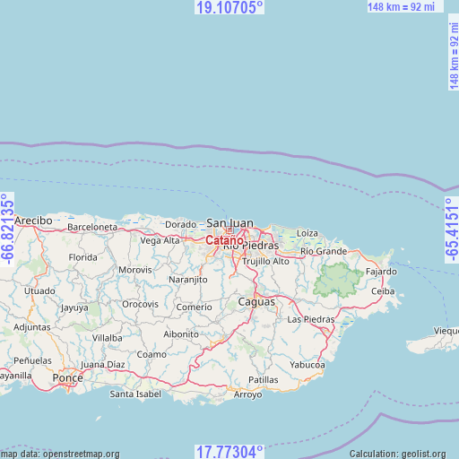
Cataño GPS coordinates[2]
18° 26' 28.824" North, 66° 7' 5.592" West
| Map corner | latitude | longitude |
|---|---|---|
| Upper-left | 19.10705°, | -66.82135° |
| Center: | 18.44134°, | -66.11822° |
| Lower-right: | 17.77304°, | -65.4151° |
| Map W x H: | 148.3×148.3 km | = 92.1×92.1mi |
| max Lat: | 18.50078° ⇑12.4% North |
| Cataño: | 18.44134° |
| min Lat: | ⇓87.6% South 17.95358° |
| min Long | Cataño | max Long |
| -67.2499° | -66.11822° | -65.30099° |
| W 68.4%⇐ | ⇒31.6% E |
Elevation
Elevation of Cataño is 1 m = 3 ft, and this is 99.5 m = 326 ft below average elevation for this country.
| Max E: |
655 m = 2149 ft | 100% |
| Avg. | 100.5 m = 330 ft | |
| Cataño | 1 m = 3 ft | |
Min E: |
1 m = 3 ft | 0% |
See also: Puerto Rico elevation on elevation.city.
Geographical zone
Cataño is located in North Torrid zone (between Equator and Tropic of Cancer). Distance of this Northern Tropic circle is 555.4 km =345.1 mi to North.| Distance of | km | miles | from Cataño |
|---|---|---|---|
| North Pole | 7956.6 | 4944 | to North |
| Arctic Circle | 5350.7 | 3324.8 | to North |
| Tropic Cancer | 555.4 | 345.1 | to North |
| Equator | 2050.5 | 1274.1 | to South |


Nearby cities:
15 places around Cataño: (largest is in red/bold)
• Bayamón
6.2 km =3.9 mi,  219°
219°
• Campanilla
12.7 km =7.9 mi,  259°
259°
• Candelaria
10.4 km =6.5 mi,  246°
246°
• Candelaria Arenas
10.8 km =6.7 mi, 255°
• Guaynabo
9.4 km =5.8 mi,  175°
175°
• Ingenio
11.4 km =7.1 mi,  270°
270°
• Levittown
6.7 km =4.2 mi,  278°
278°
• Mucarabones
11.7 km =7.3 mi,  241°
241°
• Pájaros
13.2 km =8.2 mi,  232°
232°
• Sabana Seca
7.2 km =4.5 mi, 257°
• San José
15.3 km =9.5 mi, 251°
• San Juan
3.1 km =1.9 mi,  25°
25°
• Toa Alta
14.9 km =9.3 mi, 246°
• Toa Baja
14.9 km =9.3 mi, 271°
• Trujillo Alto
15.2 km =9.4 mi,  129°
129°
Sources, notices
• [Note1] Compared only with cities in Puerto Rico existing in our database
• [Src1] Map data: © OpenStreetMap contributors (CC-BY-SA)
• [Src2] Other city data from geonames.org with taken over terms of usage.
• [Src3] Geographical zone / Annual Mean Temperature by Robert A. Rohde @ Wikipedia
