Mucarabones geodata
Mucarabones (Toa Alta) is a populated place; located in Puerto Rico in America/Puerto_Rico (GMT-4) time zone. With population of 1,690 people, there are 163 cities with bigger population in this country. Compared to other cities in Puerto Rico, 74.7% of cities are located further ↓South; 62.7% of cities are located further ←West and 56.4% of cities have higher elevation than Mucarabones. Note1


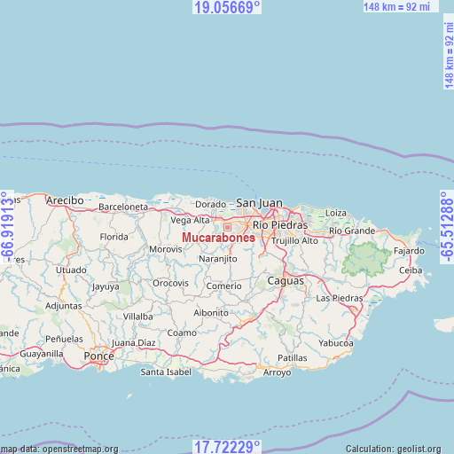
Mucarabones GPS coordinates[2]
18° 23' 26.808" North, 66° 12' 57.6" West
| Map corner | latitude | longitude |
|---|---|---|
| Upper-left | 19.05669°, | -66.91913° |
| Center: | 18.39078°, | -66.216° |
| Lower-right: | 17.72229°, | -65.51288° |
| Map W x H: | 148.4×148.4 km | = 92.2×92.2mi |
| max Lat: | 18.50078° ⇑25.3% North |
| Mucarabones: | 18.39078° |
| min Lat: | ⇓74.7% South 17.95358° |
| min Long | Mucarabones | max Long |
| -67.2499° | -66.216° | -65.30099° |
| W 62.7%⇐ | ⇒37.3% E |
Elevation
Elevation of Mucarabones is 35 m = 115 ft, and this is 65.5 m = 215 ft below average elevation for this country.
| Max E: |
655 m = 2149 ft | 56.4% |
| Avg. | 100.5 m = 330 ft | |
| Mucarabones | 35 m = 115 ft | |
Min E: |
1 m = 3 ft | 43.6% |
See also: Puerto Rico elevation on elevation.city.
Geographical zone
Mucarabones is located in North Torrid zone (between Equator and Tropic of Cancer). Distance of this Northern Tropic circle is 561.1 km =348.7 mi to North.| Distance of | km | miles | from Mucarabones |
|---|---|---|---|
| North Pole | 7962.2 | 4947.5 | to North |
| Arctic Circle | 5356.3 | 3328.2 | to North |
| Tropic Cancer | 561.1 | 348.7 | to North |
| Equator | 2044.9 | 1270.6 | to South |


Nearby cities:
15 places around Mucarabones: (largest is in red/bold)
• Bayamón
6.4 km =4 mi,  82°
82°
• Campanilla
4 km =2.5 mi,  327°
327°
• Candelaria
1.7 km =1.1 mi,  27°
27°
• Candelaria Arenas
2.9 km =1.8 mi,  357°
357°
• Dorado
9.3 km =5.8 mi,  324°
324°
• Galateo
5.5 km =3.4 mi,  235°
235°
• H. Rivera Colon
7.8 km =4.8 mi,  231°
231°
• Ingenio
5.8 km =3.6 mi,  349°
349°
• Levittown
7.5 km =4.7 mi, 28°
• Pájaros
2.5 km =1.6 mi,  182°
182°
• Río Lajas
5.5 km =3.4 mi,  274°
274°
• Sabana Seca
5.2 km =3.2 mi,  39°
39°
• San José
4.3 km =2.7 mi,  281°
281°
• Toa Alta
3.4 km =2.1 mi, 265°
• Toa Baja
7.5 km =4.7 mi, 322°
Sources, notices
• [Note1] Compared only with cities in Puerto Rico existing in our database
• [Src1] Map data: © OpenStreetMap contributors (CC-BY-SA)
• [Src2] Other city data from geonames.org with taken over terms of usage.
• [Src3] Geographical zone / Annual Mean Temperature by Robert A. Rohde @ Wikipedia
