San Juan geodata
San Juan is a capital of a political entity; located in Puerto Rico in America/Puerto_Rico (GMT-4) time zone. With population of 418,140 people, there are 0 cities with bigger population in this country. Compared to other cities in Puerto Rico, 96% of cities are located further ↓South; 70.7% of cities are located further ←West and 84% of cities have higher elevation than San Juan. Note1


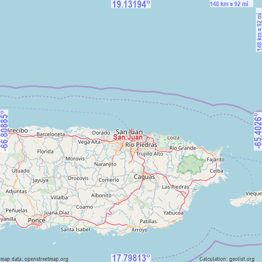
San Juan GPS coordinates[2]
18° 27' 58.788" North, 66° 6' 20.592" West
| Map corner | latitude | longitude |
|---|---|---|
| Upper-left | 19.13194°, | -66.80885° |
| Center: | 18.46633°, | -66.10572° |
| Lower-right: | 17.79813°, | -65.4026° |
| Map W x H: | 148.3×148.3 km | = 92.1×92.1mi |
| max Lat: | 18.50078° ⇑4% North |
| San Juan: | 18.46633° |
| min Lat: | ⇓96% South 17.95358° |
| min Long | San Juan | max Long |
| -67.2499° | -66.10572° | -65.30099° |
| W 70.7%⇐ | ⇒29.3% E |
Elevation
Elevation of San Juan is 11 m = 36 ft, and this is 89.5 m = 294 ft below average elevation for this country.
| Max E: |
655 m = 2149 ft | 84% |
| Avg. | 100.5 m = 330 ft | |
| San Juan | 11 m = 36 ft | |
Min E: |
1 m = 3 ft | 16% |
See also: San Juan elevation on elevation.city.
Geographical zone
San Juan is located in North Torrid zone (between Equator and Tropic of Cancer). Distance of this Northern Tropic circle is 552.7 km =343.4 mi to North.| Distance of | km | miles | from San Juan |
|---|---|---|---|
| North Pole | 7953.8 | 4942.3 | to North |
| Arctic Circle | 5347.9 | 3323 | to North |
| Tropic Cancer | 552.7 | 343.4 | to North |
| Equator | 2053.3 | 1275.9 | to South |


Nearby cities:
15 places around San Juan: (largest is in red/bold)
• Bayamón
9.2 km =5.7 mi,  214°
214°
• Campanilla
14.7 km =9.1 mi,  250°
250°
• Candelaria
12.9 km =8 mi,  237°
237°
• Candelaria Arenas
13 km =8.1 mi, 245°
• Cataño
3.1 km =1.9 mi, 205°
• Dorado
17.1 km =10.6 mi,  267°
267°
• Guaynabo
12.1 km =7.5 mi,  182°
182°
• Ingenio
13 km =8.1 mi,  258°
258°
• Levittown
8.2 km =5.1 mi, 257°
• Mucarabones
14.3 km =8.9 mi,  234°
234°
• Pájaros
16 km =9.9 mi, 227°
• Sabana Seca
9.4 km =5.8 mi, 242°
• Toa Alta
17.4 km =10.8 mi, 240°
• Toa Baja
16.4 km =10.2 mi, 261°
• Trujillo Alto
16.2 km =10.1 mi,  140°
140°
Sources, notices
• [Note1] Compared only with cities in Puerto Rico existing in our database
• [Src1] Map data: © OpenStreetMap contributors (CC-BY-SA)
• [Src2] Other city data from geonames.org with taken over terms of usage.
• [Src3] Geographical zone / Annual Mean Temperature by Robert A. Rohde @ Wikipedia
