Ceiba geodata
Ceiba is a seat of a first-order administrative division; located in Puerto Rico in America/Puerto_Rico (GMT-4) time zone. With population of 6,277 people, there are 54 cities with bigger population in this country. Compared to other cities in Puerto Rico, 52.9% of cities are located further ↓South; 98.2% of cities are located further ←West and 67.6% of cities have higher elevation than Ceiba. Note1


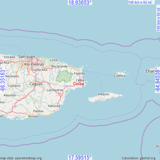
Ceiba GPS coordinates[2]
18° 15' 50.832" North, 65° 38' 54.6" West
| Map corner | latitude | longitude |
|---|---|---|
| Upper-left | 18.93053°, | -66.35163° |
| Center: | 18.26412°, | -65.6485° |
| Lower-right: | 17.59515°, | -64.94538° |
| Map W x H: | 148.5×148.5 km | = 92.3×92.3mi |
| max Lat: | 18.50078° ⇑47.1% North |
| Ceiba: | 18.26412° |
| min Lat: | ⇓52.9% South 17.95358° |
| min Long | Ceiba | max Long |
| -67.2499° | -65.6485° | -65.30099° |
| W 98.2%⇐ | ⇒1.8% E |
Elevation
Elevation of Ceiba is 24 m = 79 ft, and this is 76.5 m = 251 ft below average elevation for this country.
| Max E: |
655 m = 2149 ft | 67.6% |
| Avg. | 100.5 m = 330 ft | |
| Ceiba | 24 m = 79 ft | |
Min E: |
1 m = 3 ft | 32.4% |
See also: Puerto Rico elevation on elevation.city.
Geographical zone
Ceiba is located in North Torrid zone (between Equator and Tropic of Cancer). Distance of this Northern Tropic circle is 575.1 km =357.4 mi to North.| Distance of | km | miles | from Ceiba |
|---|---|---|---|
| North Pole | 7976.3 | 4956.2 | to North |
| Arctic Circle | 5370.4 | 3337 | to North |
| Tropic Cancer | 575.1 | 357.4 | to North |
| Equator | 2030.8 | 1261.9 | to South |


Nearby cities:
15 places around Ceiba: (largest is in red/bold)
• Aguas Claras
1.4 km =0.9 mi,  202°
202°
• Antón Ruiz
19 km =11.8 mi,  242°
242°
• Bajandas
18.4 km =11.4 mi,  229°
229°
• Daguao
5.6 km =3.5 mi,  221°
221°
• Duque
10.3 km =6.4 mi,  252°
252°
• Fajardo
6.9 km =4.3 mi,  356°
356°
• Luis M. Cintron
4.1 km =2.5 mi,  14°
14°
• Luquillo
14 km =8.7 mi,  329°
329°
• Naguabo
10.8 km =6.7 mi, 237°
• Palmer
17.8 km =11.1 mi,  311°
311°
• Peña Pobre
19.1 km =11.9 mi, 253°
• Playa Fortuna
16.4 km =10.2 mi,  321°
321°
• Punta Santiago
15.1 km =9.4 mi, 224°
• Ramos
10.8 km =6.7 mi, 321°
• Río Blanco
15.6 km =9.7 mi, 250°
Sources, notices
• [Note1] Compared only with cities in Puerto Rico existing in our database
• [Src1] Map data: © OpenStreetMap contributors (CC-BY-SA)
• [Src2] Other city data from geonames.org with taken over terms of usage.
• [Src3] Geographical zone / Annual Mean Temperature by Robert A. Rohde @ Wikipedia
