Luquillo geodata
Luquillo is a seat of a first-order administrative division; located in Puerto Rico in America/Puerto_Rico (GMT-4) time zone. With population of 8,326 people, there are 42 cities with bigger population in this country. Compared to other cities in Puerto Rico, 69.8% of cities are located further ↓South; 96% of cities are located further ←West and 83.1% of cities have higher elevation than Luquillo. Note1


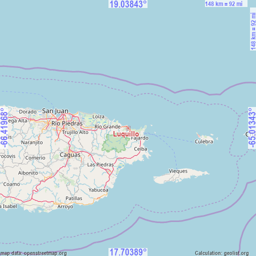
Luquillo GPS coordinates[2]
18° 22' 20.82" North, 65° 42' 59.58" West
| Map corner | latitude | longitude |
|---|---|---|
| Upper-left | 19.03843°, | -66.41968° |
| Center: | 18.37245°, | -65.71655° |
| Lower-right: | 17.70389°, | -65.01343° |
| Map W x H: | 148.4×148.4 km | = 92.2×92.2mi |
| max Lat: | 18.50078° ⇑30.2% North |
| Luquillo: | 18.37245° |
| min Lat: | ⇓69.8% South 17.95358° |
| min Long | Luquillo | max Long |
| -67.2499° | -65.71655° | -65.30099° |
| W 96%⇐ | ⇒4% E |
Elevation
Elevation of Luquillo is 12 m = 39 ft, and this is 88.5 m = 290 ft below average elevation for this country.
| Max E: |
655 m = 2149 ft | 83.1% |
| Avg. | 100.5 m = 330 ft | |
| Luquillo | 12 m = 39 ft | |
Min E: |
1 m = 3 ft | 16.9% |
See also: Puerto Rico elevation on elevation.city.
Geographical zone
Luquillo is located in North Torrid zone (between Equator and Tropic of Cancer). Distance of this Northern Tropic circle is 563.1 km =349.9 mi to North.| Distance of | km | miles | from Luquillo |
|---|---|---|---|
| North Pole | 7964.2 | 4948.7 | to North |
| Arctic Circle | 5358.3 | 3329.5 | to North |
| Tropic Cancer | 563.1 | 349.9 | to North |
| Equator | 2042.8 | 1269.3 | to South |


Nearby cities:
15 places around Luquillo: (largest is in red/bold)
• Aguas Claras
14.9 km =9.3 mi,  153°
153°
• Bartolo
12.9 km =8 mi,  264°
264°
• Ceiba
14 km =8.7 mi, 149°
• Daguao
16.6 km =10.3 mi,  167°
167°
• Duque
15.3 km =9.5 mi,  189°
189°
• Fajardo
8.5 km =5.3 mi,  127°
127°
• Hato Candal
7.4 km =4.6 mi,  271°
271°
• La Dolores
14.7 km =9.1 mi, 271°
• Luis M. Cintron
11.5 km =7.1 mi, 134°
• Palmer
6.1 km =3.8 mi, 267°
• Playa Fortuna
3.1 km =1.9 mi,  284°
284°
• Ramos
3.7 km =2.3 mi, 173°
• Río Grande
12.1 km =7.5 mi, 274°
• Suárez
15.8 km =9.8 mi,  293°
293°
• Vieques
13.6 km =8.5 mi,  295°
295°
Sources, notices
• [Note1] Compared only with cities in Puerto Rico existing in our database
• [Src1] Map data: © OpenStreetMap contributors (CC-BY-SA)
• [Src2] Other city data from geonames.org with taken over terms of usage.
• [Src3] Geographical zone / Annual Mean Temperature by Robert A. Rohde @ Wikipedia
