Antón Ruiz geodata
Antón Ruiz (Humacao) is a populated place; located in Puerto Rico in America/Puerto_Rico (GMT-4) time zone. With population of 1,764 people, there are 158 cities with bigger population in this country. Compared to other cities in Puerto Rico, 58.2% of cities are located further ↑North; 92% of cities are located further ←West and 60% of cities have higher elevation than Antón Ruiz. Note1


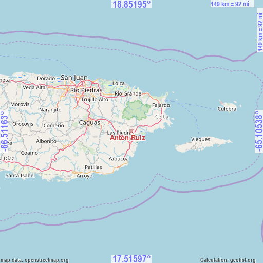
Antón Ruiz GPS coordinates[2]
18° 11' 6.864" North, 65° 48' 30.6" West
| Map corner | latitude | longitude |
|---|---|---|
| Upper-left | 18.85195°, | -66.51163° |
| Center: | 18.18524°, | -65.8085° |
| Lower-right: | 17.51597°, | -65.10538° |
| Map W x H: | 148.5×148.6 km | = 92.3×92.3mi |
| max Lat: | 18.50078° ⇑58.2% North |
| Antón Ruiz: | 18.18524° |
| min Lat: | ⇓41.8% South 17.95358° |
| min Long | Antón Ruiz | max Long |
| -67.2499° | -65.8085° | -65.30099° |
| W 92%⇐ | ⇒8% E |
Elevation
Elevation of Antón Ruiz is 31 m = 102 ft, and this is 69.5 m = 228 ft below average elevation for this country.
| Max E: |
655 m = 2149 ft | 60% |
| Avg. | 100.5 m = 330 ft | |
| Antón Ruiz | 31 m = 102 ft | |
Min E: |
1 m = 3 ft | 40% |
See also: Puerto Rico elevation on elevation.city.
Geographical zone
Antón Ruiz is located in North Torrid zone (between Equator and Tropic of Cancer). Distance of this Northern Tropic circle is 583.9 km =362.8 mi to North.| Distance of | km | miles | from Antón Ruiz |
|---|---|---|---|
| North Pole | 7985.1 | 4961.7 | to North |
| Arctic Circle | 5379.2 | 3342.5 | to North |
| Tropic Cancer | 583.9 | 362.8 | to North |
| Equator | 2022 | 1256.4 | to South |


Nearby cities:
15 places around Antón Ruiz: (largest is in red/bold)
• Bajandas
4.2 km =2.6 mi,  137°
137°
• Benitez
12.3 km =7.6 mi,  322°
322°
• Boqueron
4.9 km =3 mi,  300°
300°
• Candelero Arriba
9.7 km =6 mi,  197°
197°
• Comunas
11.5 km =7.1 mi, 198°
• Duque
9.1 km =5.7 mi,  50°
50°
• El Mangó
9.3 km =5.8 mi,  305°
305°
• Humacao
4.4 km =2.7 mi,  206°
206°
• La Fermina
4.9 km =3 mi,  257°
257°
• Las Piedras
6.1 km =3.8 mi,  267°
267°
• Naguabo
8.3 km =5.2 mi,  69°
69°
• Peña Pobre
3.7 km =2.3 mi,  336°
336°
• Pueblito del Rio
7.5 km =4.7 mi, 309°
• Punta Santiago
6.7 km =4.2 mi,  108°
108°
• Río Blanco
4.2 km =2.6 mi,  29°
29°
Sources, notices
• [Note1] Compared only with cities in Puerto Rico existing in our database
• [Src1] Map data: © OpenStreetMap contributors (CC-BY-SA)
• [Src2] Other city data from geonames.org with taken over terms of usage.
• [Src3] Geographical zone / Annual Mean Temperature by Robert A. Rohde @ Wikipedia
