Daguao geodata
Daguao (Naguabo) is a populated place; located in Puerto Rico in America/Puerto_Rico (GMT-4) time zone. With population of 1,488 people, there are 174 cities with bigger population in this country. Compared to other cities in Puerto Rico, 52.9% of cities are located further ↑North; 96.9% of cities are located further ←West and 56.4% of cities have higher elevation than Daguao. Note1


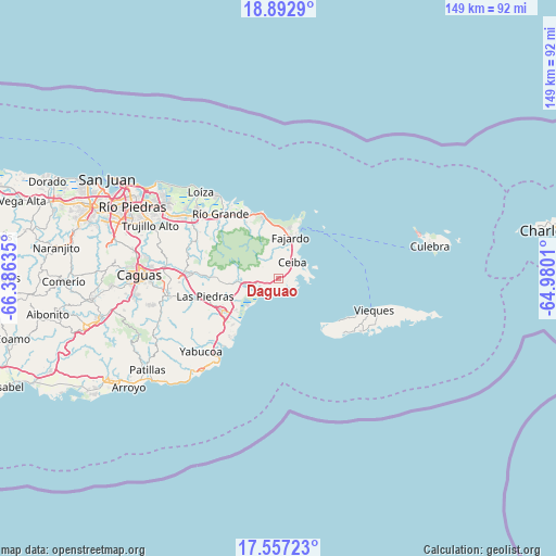
Daguao GPS coordinates[2]
18° 13' 34.86" North, 65° 40' 59.592" West
| Map corner | latitude | longitude |
|---|---|---|
| Upper-left | 18.8929°, | -66.38635° |
| Center: | 18.22635°, | -65.68322° |
| Lower-right: | 17.55723°, | -64.9801° |
| Map W x H: | 148.5×148.5 km | = 92.3×92.3mi |
| max Lat: | 18.50078° ⇑52.9% North |
| Daguao: | 18.22635° |
| min Lat: | ⇓47.1% South 17.95358° |
| min Long | Daguao | max Long |
| -67.2499° | -65.68322° | -65.30099° |
| W 96.9%⇐ | ⇒3.1% E |
Elevation
Elevation of Daguao is 35 m = 115 ft, and this is 65.5 m = 215 ft below average elevation for this country.
| Max E: |
655 m = 2149 ft | 56.4% |
| Avg. | 100.5 m = 330 ft | |
| Daguao | 35 m = 115 ft | |
Min E: |
1 m = 3 ft | 43.6% |
See also: Puerto Rico elevation on elevation.city.
Geographical zone
Daguao is located in North Torrid zone (between Equator and Tropic of Cancer). Distance of this Northern Tropic circle is 579.3 km =360 mi to North.| Distance of | km | miles | from Daguao |
|---|---|---|---|
| North Pole | 7980.5 | 4958.9 | to North |
| Arctic Circle | 5374.6 | 3339.6 | to North |
| Tropic Cancer | 579.3 | 360 | to North |
| Equator | 2026.6 | 1259.3 | to South |


Nearby cities:
15 places around Daguao: (largest is in red/bold)
• Aguas Claras
4.3 km =2.7 mi,  46°
46°
• Antón Ruiz
14 km =8.7 mi,  250°
250°
• Bajandas
12.9 km =8 mi,  233°
233°
• Boqueron
17.6 km =10.9 mi,  263°
263°
• Ceiba
5.6 km =3.5 mi,  41°
41°
• Duque
6.3 km =3.9 mi,  280°
280°
• Fajardo
11.5 km =7.1 mi,  16°
16°
• Humacao
17.5 km =10.9 mi,  240°
240°
• Luis M. Cintron
9.4 km =5.8 mi,  30°
30°
• Luquillo
16.6 km =10.3 mi,  347°
347°
• Naguabo
5.7 km =3.5 mi, 253°
• Peña Pobre
14.7 km =9.1 mi,  265°
265°
• Punta Santiago
9.6 km =6 mi, 225°
• Ramos
13 km =8.1 mi, 346°
• Río Blanco
11.2 km =7 mi, 265°
Sources, notices
• [Note1] Compared only with cities in Puerto Rico existing in our database
• [Src1] Map data: © OpenStreetMap contributors (CC-BY-SA)
• [Src2] Other city data from geonames.org with taken over terms of usage.
• [Src3] Geographical zone / Annual Mean Temperature by Robert A. Rohde @ Wikipedia
