Fajardo geodata
Fajardo is a seat of a first-order administrative division; located in Puerto Rico in America/Puerto_Rico (GMT-4) time zone. With population of 34,068 people, there are 9 cities with bigger population in this country. Compared to other cities in Puerto Rico, 60.4% of cities are located further ↓South; 97.8% of cities are located further ←West and 77.8% of cities have higher elevation than Fajardo. Note1


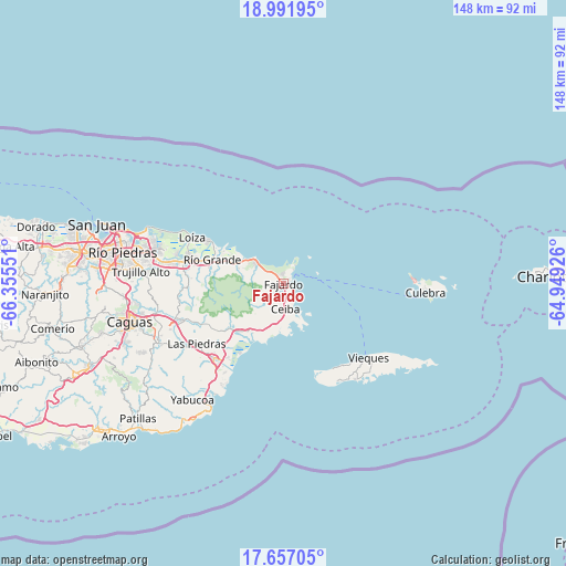
Fajardo GPS coordinates[2]
18° 19' 32.844" North, 65° 39' 8.568" West
| Map corner | latitude | longitude |
|---|---|---|
| Upper-left | 18.99195°, | -66.35551° |
| Center: | 18.32579°, | -65.65238° |
| Lower-right: | 17.65705°, | -64.94926° |
| Map W x H: | 148.4×148.4 km | = 92.2×92.2mi |
| max Lat: | 18.50078° ⇑39.6% North |
| Fajardo: | 18.32579° |
| min Lat: | ⇓60.4% South 17.95358° |
| min Long | Fajardo | max Long |
| -67.2499° | -65.65238° | -65.30099° |
| W 97.8%⇐ | ⇒2.2% E |
Elevation
Elevation of Fajardo is 16 m = 52 ft, and this is 84.5 m = 277 ft below average elevation for this country.
| Max E: |
655 m = 2149 ft | 77.8% |
| Avg. | 100.5 m = 330 ft | |
| Fajardo | 16 m = 52 ft | |
Min E: |
1 m = 3 ft | 22.2% |
See also: Puerto Rico elevation on elevation.city.
Geographical zone
Fajardo is located in North Torrid zone (between Equator and Tropic of Cancer). Distance of this Northern Tropic circle is 568.3 km =353.1 mi to North.| Distance of | km | miles | from Fajardo |
|---|---|---|---|
| North Pole | 7969.4 | 4952 | to North |
| Arctic Circle | 5363.5 | 3332.7 | to North |
| Tropic Cancer | 568.3 | 353.1 | to North |
| Equator | 2037.6 | 1266.1 | to South |


Nearby cities:
15 places around Fajardo: (largest is in red/bold)
• Aguas Claras
8.1 km =5 mi,  180°
180°
• Bartolo
20 km =12.4 mi,  281°
281°
• Ceiba
6.9 km =4.3 mi, 176°
• Daguao
11.5 km =7.1 mi,  196°
196°
• Duque
13.7 km =8.5 mi,  223°
223°
• Hato Candal
15.2 km =9.4 mi,  290°
290°
• Luis M. Cintron
3.3 km =2.1 mi,  153°
153°
• Luquillo
8.5 km =5.3 mi,  307°
307°
• Naguabo
15.4 km =9.6 mi,  214°
214°
• Palmer
13.8 km =8.6 mi, 291°
• Playa Fortuna
11.5 km =7.1 mi,  301°
301°
• Punta Santiago
20.4 km =12.7 mi, 209°
• Ramos
6.5 km =4 mi, 283°
• Río Blanco
18.7 km =11.6 mi,  230°
230°
• Río Grande
19.8 km =12.3 mi, 287°
Sources, notices
• [Note1] Compared only with cities in Puerto Rico existing in our database
• [Src1] Map data: © OpenStreetMap contributors (CC-BY-SA)
• [Src2] Other city data from geonames.org with taken over terms of usage.
• [Src3] Geographical zone / Annual Mean Temperature by Robert A. Rohde @ Wikipedia
