H. Rivera Colon geodata
H. Rivera Colon (Toa Alta) is a populated place; located in Puerto Rico in America/Puerto_Rico (GMT-4) time zone. With population of 2,379 people, there are 117 cities with bigger population in this country. Compared to other cities in Puerto Rico, 64% of cities are located further ↓South; 53.8% of cities are located further ←West and 79.1% of cities have lower elevation than H. Rivera Colon. Note1


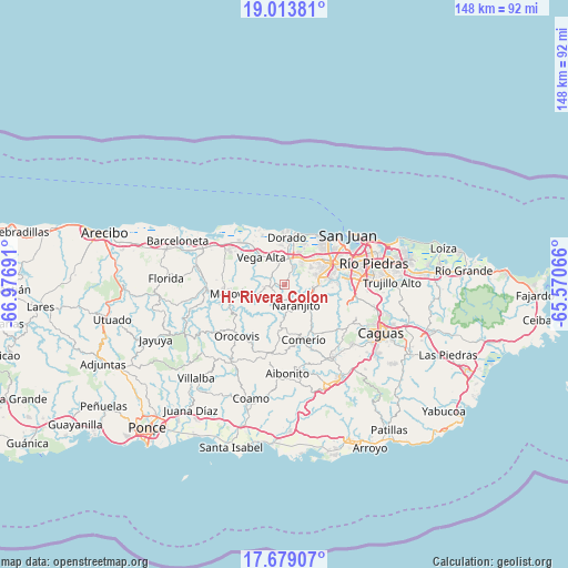
H. Rivera Colon GPS coordinates[2]
18° 20' 51.828" North, 66° 16' 25.608" West
| Map corner | latitude | longitude |
|---|---|---|
| Upper-left | 19.01381°, | -66.97691° |
| Center: | 18.34773°, | -66.27378° |
| Lower-right: | 17.67907°, | -65.57066° |
| Map W x H: | 148.4×148.4 km | = 92.2×92.2mi |
| max Lat: | 18.50078° ⇑36% North |
| H. Rivera Colon: | 18.34773° |
| min Lat: | ⇓64% South 17.95358° |
| min Long | H. Rivera Colon | max Long |
| -67.2499° | -66.27378° | -65.30099° |
| W 53.8%⇐ | ⇒46.2% E |
Elevation
Elevation of H. Rivera Colon is 142 m = 466 ft, and this is 41.5 m = 136 ft above average elevation for this country.
| Max E: |
655 m = 2149 ft | 20.9% |
| H. Rivera Colon | 142 m 466 ft | |
| Avg. | 100.5 m = 330 ft | |
Min E: |
1 m = 3 ft | 79.1% |
See also: Puerto Rico elevation on elevation.city.
Geographical zone
H. Rivera Colon is located in North Torrid zone (between Equator and Tropic of Cancer). Distance of this Northern Tropic circle is 565.8 km =351.6 mi to North.| Distance of | km | miles | from H. Rivera Colon |
|---|---|---|---|
| North Pole | 7967 | 4950.5 | to North |
| Arctic Circle | 5361.1 | 3331.2 | to North |
| Tropic Cancer | 565.8 | 351.6 | to North |
| Equator | 2040.1 | 1267.7 | to South |


Nearby cities:
15 places around H. Rivera Colon: (largest is in red/bold)
• Campanilla
9.1 km =5.7 mi,  25°
25°
• Candelaria
9.3 km =5.8 mi,  47°
47°
• Candelaria Arenas
9.7 km =6 mi,  37°
37°
• Corozal
4.6 km =2.9 mi,  260°
260°
• Galateo
2.3 km =1.4 mi, 44°
• Ingenio
11.6 km =7.2 mi, 25°
• Mucarabones
7.8 km =4.8 mi, 51°
• Naranjito
6 km =3.7 mi,  149°
149°
• Pájaros
6.4 km =4 mi,  68°
68°
• Río Lajas
5.3 km =3.3 mi,  7°
7°
• San Antonio
11.6 km =7.2 mi,  344°
344°
• San José
5.9 km =3.7 mi,  18°
18°
• Toa Alta
5.3 km =3.3 mi, 30°
• Toa Baja
10.8 km =6.7 mi, 7°
• Vega Alta
9.4 km =5.8 mi,  319°
319°
Sources, notices
• [Note1] Compared only with cities in Puerto Rico existing in our database
• [Src1] Map data: © OpenStreetMap contributors (CC-BY-SA)
• [Src2] Other city data from geonames.org with taken over terms of usage.
• [Src3] Geographical zone / Annual Mean Temperature by Robert A. Rohde @ Wikipedia
