Galateo geodata
Galateo (Toa Alta) is a populated place; located in Puerto Rico in America/Puerto_Rico (GMT-4) time zone. With population of 2,705 people, there are 109 cities with bigger population in this country. Compared to other cities in Puerto Rico, 67.1% of cities are located further ↓South; 56.4% of cities are located further ←West and 61.8% of cities have higher elevation than Galateo. Note1


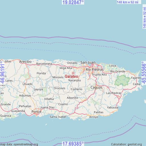
Galateo GPS coordinates[2]
18° 21' 44.82" North, 66° 15' 31.608" West
| Map corner | latitude | longitude |
|---|---|---|
| Upper-left | 19.02847°, | -66.96191° |
| Center: | 18.36245°, | -66.25878° |
| Lower-right: | 17.69385°, | -65.55566° |
| Map W x H: | 148.4×148.4 km | = 92.2×92.2mi |
| max Lat: | 18.50078° ⇑32.9% North |
| Galateo: | 18.36245° |
| min Lat: | ⇓67.1% South 17.95358° |
| min Long | Galateo | max Long |
| -67.2499° | -66.25878° | -65.30099° |
| W 56.4%⇐ | ⇒43.6% E |
Elevation
Elevation of Galateo is 29 m = 95 ft, and this is 71.5 m = 235 ft below average elevation for this country.
| Max E: |
655 m = 2149 ft | 61.8% |
| Avg. | 100.5 m = 330 ft | |
| Galateo | 29 m = 95 ft | |
Min E: |
1 m = 3 ft | 38.2% |
See also: Puerto Rico elevation on elevation.city.
Geographical zone
Galateo is located in North Torrid zone (between Equator and Tropic of Cancer). Distance of this Northern Tropic circle is 564.2 km =350.6 mi to North.| Distance of | km | miles | from Galateo |
|---|---|---|---|
| North Pole | 7965.3 | 4949.4 | to North |
| Arctic Circle | 5359.5 | 3330.2 | to North |
| Tropic Cancer | 564.2 | 350.6 | to North |
| Equator | 2041.7 | 1268.7 | to South |


Nearby cities:
15 places around Galateo: (largest is in red/bold)
• Campanilla
6.9 km =4.3 mi,  19°
19°
• Candelaria
7 km =4.3 mi,  48°
48°
• Candelaria Arenas
7.5 km =4.7 mi,  35°
35°
• Corozal
6.6 km =4.1 mi,  248°
248°
• H. Rivera Colon
2.3 km =1.4 mi,  224°
224°
• Ingenio
9.5 km =5.9 mi, 21°
• Mucarabones
5.5 km =3.4 mi,  55°
55°
• Naranjito
7 km =4.3 mi,  167°
167°
• Pájaros
4.5 km =2.8 mi,  81°
81°
• Río Lajas
3.7 km =2.3 mi,  345°
345°
• Sabana Seca
10.6 km =6.6 mi, 47°
• San José
4 km =2.5 mi,  4°
4°
• Toa Alta
3.1 km =1.9 mi, 21°
• Toa Baja
9.1 km =5.7 mi,  359°
359°
• Vega Alta
9.4 km =5.8 mi,  305°
305°
Sources, notices
• [Note1] Compared only with cities in Puerto Rico existing in our database
• [Src1] Map data: © OpenStreetMap contributors (CC-BY-SA)
• [Src2] Other city data from geonames.org with taken over terms of usage.
• [Src3] Geographical zone / Annual Mean Temperature by Robert A. Rohde @ Wikipedia
