Palomas geodata
Palomas (Comerío) is a populated place; located in Puerto Rico in America/Puerto_Rico (GMT-4) time zone. With population of 1,742 people, there are 159 cities with bigger population in this country. Compared to other cities in Puerto Rico, 51.1% of cities are located further ↑North; 57.3% of cities are located further ←West and 98.7% of cities have lower elevation than Palomas. Note1


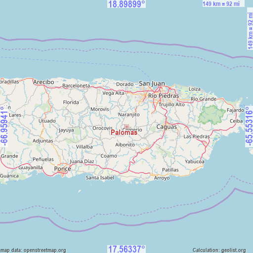
Palomas GPS coordinates[2]
18° 13' 56.856" North, 66° 15' 22.608" West
| Map corner | latitude | longitude |
|---|---|---|
| Upper-left | 18.89899°, | -66.95941° |
| Center: | 18.23246°, | -66.25628° |
| Lower-right: | 17.56337°, | -65.55316° |
| Map W x H: | 148.5×148.5 km | = 92.3×92.3mi |
| max Lat: | 18.50078° ⇑51.1% North |
| Palomas: | 18.23246° |
| min Lat: | ⇓48.9% South 17.95358° |
| min Long | Palomas | max Long |
| -67.2499° | -66.25628° | -65.30099° |
| W 57.3%⇐ | ⇒42.7% E |
Elevation
Elevation of Palomas is 597 m = 1959 ft, and this is 496.5 m = 1629 ft above average elevation for this country.
| Max E: |
655 m = 2149 ft | 1.3% |
| Palomas | 597 m 1959 ft | |
| Avg. | 100.5 m = 330 ft | |
Min E: |
1 m = 3 ft | 98.7% |
See also: Puerto Rico elevation on elevation.city.
Geographical zone
Palomas is located in North Torrid zone (between Equator and Tropic of Cancer). Distance of this Northern Tropic circle is 578.7 km =359.6 mi to North.| Distance of | km | miles | from Palomas |
|---|---|---|---|
| North Pole | 7979.8 | 4958.4 | to North |
| Arctic Circle | 5373.9 | 3339.2 | to North |
| Tropic Cancer | 578.7 | 359.6 | to North |
| Equator | 2027.3 | 1259.7 | to South |


Nearby cities:
15 places around Palomas: (largest is in red/bold)
• Aibonito
10.3 km =6.4 mi,  185°
185°
• Barranquitas
7.3 km =4.5 mi,  226°
226°
• Cidra
11.8 km =7.3 mi,  122°
122°
• Comerío
3.6 km =2.2 mi, 116°
• Corozal
13.7 km =8.5 mi,  332°
332°
• Galateo
14.5 km =9 mi,  358°
358°
• H. Rivera Colon
12.9 km =8 mi,  351°
351°
• Naranjito
7.7 km =4.8 mi,  8°
8°
• Orocovis
14.2 km =8.8 mi,  267°
267°
• Parcelas La Milagrosa
9.9 km =6.2 mi,  133°
133°
• Parcelas Nuevas
13.6 km =8.5 mi,  139°
139°
• Pastos
12.8 km =8 mi,  181°
181°
• Pájaros
15.7 km =9.8 mi,  15°
15°
• Santa Clara
13.6 km =8.5 mi,  96°
96°
• Sumidero
13.6 km =8.5 mi, 96°
Sources, notices
• [Note1] Compared only with cities in Puerto Rico existing in our database
• [Src1] Map data: © OpenStreetMap contributors (CC-BY-SA)
• [Src2] Other city data from geonames.org with taken over terms of usage.
• [Src3] Geographical zone / Annual Mean Temperature by Robert A. Rohde @ Wikipedia
