Sesimbra geodata
Sesimbra (District of Setúbal) is a populated place; located in Portugal in Europe/Lisbon (GMT+1) time zone. With population of 41,134 people, there are 27 cities with bigger population in this country. Compared to other cities in Portugal, 81.3% of cities are located further ↑North; 77.7% of cities are located further →East and 83.6% of cities have higher elevation than Sesimbra. Note1
Administrative division(s):
- Level 1: District of Setúbal
- Level 2: Sesimbra
- Level 3: Sesimbra (Santiago)


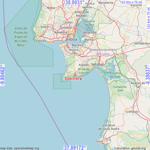
Sesimbra GPS coordinates[2]
38° 26' 40.236" North, 9° 6' 5.364" West
| Map corner | latitude | longitude |
|---|---|---|
| Upper-left | 38.9931°, | -9.80462° |
| Center: | 38.44451°, | -9.10149° |
| Lower-right: | 37.89172°, | -8.39837° |
| Map W x H: | 122.5×122.5 km | = 76.1×76.1mi |
| max Lat: | 42.11337° ⇑81.3% North |
| Sesimbra: | 38.44451° |
| min Lat: | ⇓18.7% South 32.6448° |
| min Long | Sesimbra | max Long |
| -31.17847° | -9.10149° | -6.27308° |
| W 22.3%⇐ | ⇒77.7% E |
Elevation
Elevation of Sesimbra is 26 m = 85 ft, and this is 151 m = 495 ft below average elevation for this country.
| Max E: |
1008 m = 3307 ft | 83.6% |
| Avg. | 177 m = 581 ft | |
| Sesimbra | 26 m = 85 ft | |
Min E: |
-128 m = -420 ft | 16.4% |
See also: Sesimbra elevation on elevation.city.
Geographical zone
Sesimbra is located in North temperate zone (between Tropic of Cancer and the Arctic Circle). Distance of this Northern Tropic circle is 1668.7 km =1036.9 mi to South.| Distance of | km | miles | from Sesimbra |
|---|---|---|---|
| North Pole | 5732.4 | 3561.9 | to North |
| Arctic Circle | 3126.5 | 1942.7 | to North |
| Tropic Cancer | 1668.7 | 1036.9 | to South |
| Equator | 4274.6 | 2656.1 | to South |


Nearby cities:
15 places around Sesimbra: (largest is in red/bold)
• Aldeia de Paio Pires
19.2 km =11.9 mi,  4°
4°
• Alhos Vedros
24.3 km =15.1 mi,  16°
16°
• Amora
20.6 km =12.8 mi,  356°
356°
• Arrentela
20.1 km =12.5 mi, 359°
• Azeitão
11.3 km =7 mi,  42°
42°
• Charneca de Caparica
21.1 km =13.1 mi,  337°
337°
• Corroios
22.2 km =13.8 mi,  348°
348°
• Laranjeira
23.9 km =14.9 mi, 349°
• Palmela
22.3 km =13.9 mi,  51°
51°
• Quinta Do Conde
14.4 km =8.9 mi, 20°
• Quinta do Anjo
19.5 km =12.1 mi, 45°
• Santo António da Charneca
21.1 km =13.1 mi, 17°
• Seixal
21.7 km =13.5 mi, 0°
• Setúbal
20.6 km =12.8 mi,  64°
64°
• Sobreda
24.1 km =15 mi, 341°
Sources, notices
• [Note1] Compared only with cities in Portugal existing in our database
• [Src1] Map data: © OpenStreetMap contributors (CC-BY-SA)
• [Src2] Other city data from geonames.org with taken over terms of usage.
• [Src3] Geographical zone / Annual Mean Temperature by Robert A. Rohde @ Wikipedia
