Comporta geodata
Comporta (District of Setúbal) is a populated place; located in Portugal in Europe/Lisbon (GMT+1) time zone. With population of 1,268 people, there are 719 cities with bigger population in this country. Compared to other cities in Portugal, 81.8% of cities are located further ↑North; 67.8% of cities are located further →East and 96.2% of cities have higher elevation than Comporta. Note1


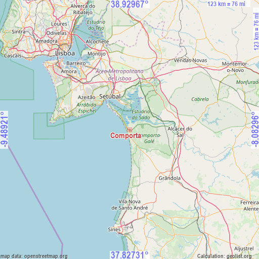
Comporta GPS coordinates[2]
38° 22' 50.124" North, 8° 47' 9.888" West
| Map corner | latitude | longitude |
|---|---|---|
| Upper-left | 38.92967°, | -9.48921° |
| Center: | 38.38059°, | -8.78608° |
| Lower-right: | 37.82731°, | -8.08296° |
| Map W x H: | 122.6×122.6 km | = 76.2×76.2mi |
| max Lat: | 42.11337° ⇑81.8% North |
| Comporta: | 38.38059° |
| min Lat: | ⇓18.2% South 32.6448° |
| min Long | Comporta | max Long |
| -31.17847° | -8.78608° | -6.27308° |
| W 32.2%⇐ | ⇒67.8% E |
Elevation
Elevation of Comporta is 9 m = 30 ft, and this is 168 m = 551 ft below average elevation for this country.
| Max E: |
1008 m = 3307 ft | 96.2% |
| Avg. | 177 m = 581 ft | |
| Comporta | 9 m = 30 ft | |
Min E: |
-128 m = -420 ft | 3.8% |
See also: Portugal elevation on elevation.city.
Geographical zone
Comporta is located in North temperate zone (between Tropic of Cancer and the Arctic Circle). Distance of this Northern Tropic circle is 1661.6 km =1032.5 mi to South.| Distance of | km | miles | from Comporta |
|---|---|---|---|
| North Pole | 5739.5 | 3566.4 | to North |
| Arctic Circle | 3133.7 | 1947.2 | to North |
| Tropic Cancer | 1661.6 | 1032.5 | to South |
| Equator | 4267.5 | 2651.7 | to South |


Nearby cities:
15 places around Comporta: (largest is in red/bold)
• Alcácer do Sal
23.7 km =14.7 mi,  91°
91°
• Aldeia de Paio Pires
36.9 km =22.9 mi,  315°
315°
• Alhos Vedros
36.8 km =22.9 mi,  325°
325°
• Azeitão
25.1 km =15.6 mi,  307°
307°
• Grândola
29.6 km =18.4 mi,  139°
139°
• Moita
34.9 km =21.7 mi, 329°
• Palmela
23.2 km =14.4 mi, 334°
• Pinhal Novo
30 km =18.6 mi,  338°
338°
• Quinta Do Conde
30.4 km =18.9 mi, 312°
• Quinta do Anjo
24.8 km =15.4 mi, 326°
• Santo André
35.6 km =22.1 mi,  179°
179°
• Santo António da Charneca
34.6 km =21.5 mi, 322°
• Sarilhos Pequenos
37.6 km =23.4 mi, 332°
• Sesimbra
28.4 km =17.6 mi,  284°
284°
• Setúbal
18.3 km =11.4 mi, 330°
Sources, notices
• [Note1] Compared only with cities in Portugal existing in our database
• [Src1] Map data: © OpenStreetMap contributors (CC-BY-SA)
• [Src2] Other city data from geonames.org with taken over terms of usage.
• [Src3] Geographical zone / Annual Mean Temperature by Robert A. Rohde @ Wikipedia
