Sagres geodata
Sagres (Faro) is a populated place; located in Portugal in Europe/Lisbon (GMT+1) time zone. With population of 1,939 people, there are 654 cities with bigger population in this country. Compared to other cities in Portugal, 96% of cities are located further ↑North; 72.3% of cities are located further →East and 81.4% of cities have higher elevation than Sagres. Note1


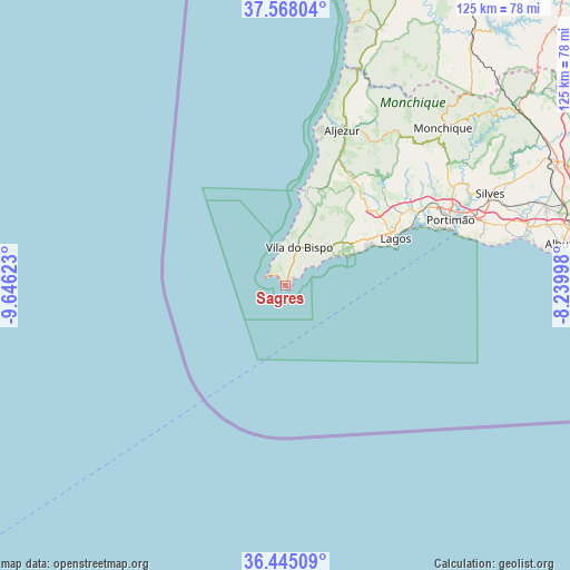
Sagres GPS coordinates[2]
37° 0' 31.104" North, 8° 56' 35.196" West
| Map corner | latitude | longitude |
|---|---|---|
| Upper-left | 37.56804°, | -9.64623° |
| Center: | 37.00864°, | -8.94311° |
| Lower-right: | 36.44509°, | -8.23998° |
| Map W x H: | 124.9×124.9 km | = 77.6×77.6mi |
| max Lat: | 42.11337° ⇑96% North |
| Sagres: | 37.00864° |
| min Lat: | ⇓4% South 32.6448° |
| min Long | Sagres | max Long |
| -31.17847° | -8.94311° | -6.27308° |
| W 27.7%⇐ | ⇒72.3% E |
Elevation
Elevation of Sagres is 31 m = 102 ft, and this is 146 m = 479 ft below average elevation for this country.
| Max E: |
1008 m = 3307 ft | 81.4% |
| Avg. | 177 m = 581 ft | |
| Sagres | 31 m = 102 ft | |
Min E: |
-128 m = -420 ft | 18.6% |
See also: Portugal elevation on elevation.city.
Geographical zone
Sagres is located in North temperate zone (between Tropic of Cancer and the Arctic Circle). Distance of this Northern Tropic circle is 1509.1 km =937.7 mi to South.| Distance of | km | miles | from Sagres |
|---|---|---|---|
| North Pole | 5892.1 | 3661.2 | to North |
| Arctic Circle | 3286.2 | 2041.9 | to North |
| Tropic Cancer | 1509.1 | 937.7 | to South |
| Equator | 4115 | 2556.9 | to South |


Nearby cities:
15 places around Sagres: (largest is in red/bold)
• Aljezur
36.6 km =22.7 mi,  20°
20°
• Alvor
34 km =21.1 mi,  66°
66°
• Barão de São João
20.6 km =12.8 mi,  45°
45°
• Bensafrim
24.7 km =15.3 mi, 48°
• Carvoeiro
43.3 km =26.9 mi,  76°
76°
• Estômbar
43.4 km =27 mi, 69°
• Ferragudo
39.8 km =24.7 mi, 71°
• Lagoa
45.7 km =28.4 mi, 72°
• Lagos
26 km =16.2 mi, 66°
• Marmelete
41.4 km =25.7 mi,  36°
36°
• Mexilhoeira Grande
33.6 km =20.9 mi,  60°
60°
• Parchal
40.5 km =25.2 mi, 69°
• Portimão
38.8 km =24.1 mi, 68°
• Senhora da Luz
21.1 km =13.1 mi, 65°
• Vila do Bispo
8.8 km =5.5 mi, 18°
Sources, notices
• [Note1] Compared only with cities in Portugal existing in our database
• [Src1] Map data: © OpenStreetMap contributors (CC-BY-SA)
• [Src2] Other city data from geonames.org with taken over terms of usage.
• [Src3] Geographical zone / Annual Mean Temperature by Robert A. Rohde @ Wikipedia
