Ramada geodata
Ramada (Lisbon) is a populated place; located in Portugal in Europe/Lisbon (GMT+1) time zone. With population of 17,535 people, there are 118 cities with bigger population in this country. Compared to other cities in Portugal, 68.7% of cities are located further ↑North; 82.1% of cities are located further →East and 50.7% of cities have lower elevation than Ramada. Note1


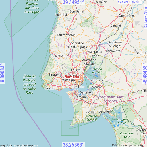
Ramada GPS coordinates[2]
38° 48' 13.248" North, 9° 11' 15.72" West
| Map corner | latitude | longitude |
|---|---|---|
| Upper-left | 39.34951°, | -9.89083° |
| Center: | 38.80368°, | -9.1877° |
| Lower-right: | 38.25363°, | -8.48458° |
| Map W x H: | 121.9×121.9 km | = 75.7×75.7mi |
| max Lat: | 42.11337° ⇑68.7% North |
| Ramada: | 38.80368° |
| min Lat: | ⇓31.3% South 32.6448° |
| min Long | Ramada | max Long |
| -31.17847° | -9.1877° | -6.27308° |
| W 17.9%⇐ | ⇒82.1% E |
Elevation
Elevation of Ramada is 116 m = 381 ft, and this is 61 m = 200 ft below average elevation for this country.
| Max E: |
1008 m = 3307 ft | 49.3% |
| Avg. | 177 m = 581 ft | |
| Ramada | 116 m = 381 ft | |
Min E: |
-128 m = -420 ft | 50.7% |
See also: Portugal elevation on elevation.city.
Geographical zone
Ramada is located in North temperate zone (between Tropic of Cancer and the Arctic Circle). Distance of this Northern Tropic circle is 1708.6 km =1061.7 mi to South.| Distance of | km | miles | from Ramada |
|---|---|---|---|
| North Pole | 5692.5 | 3537.2 | to North |
| Arctic Circle | 3086.6 | 1917.9 | to North |
| Tropic Cancer | 1708.6 | 1061.7 | to South |
| Equator | 4314.6 | 2681 | to South |


Nearby cities:
15 places around Ramada: (largest is in red/bold)
• Amadora
6.7 km =4.2 mi,  213°
213°
• Apelação
4.9 km =3 mi,  76°
76°
• Benfica
6 km =3.7 mi,  192°
192°
• Camarate
5.2 km =3.2 mi,  90°
90°
• Caneças
3.5 km =2.2 mi,  287°
287°
• Charneca
4.4 km =2.7 mi,  120°
120°
• Famões
2.6 km =1.6 mi,  228°
228°
• Loures
3.5 km =2.2 mi,  28°
28°
• Odivelas
1.3 km =0.8 mi,  164°
164°
• Olival do Basto
2.3 km =1.4 mi,  127°
127°
• Pontinha
4.1 km =2.5 mi, 194°
• Prior Velho
5.9 km =3.7 mi,  102°
102°
• Póvoa de Santo Adrião
1.9 km =1.2 mi, 102°
• Santo Antão do Tojal
6.7 km =4.2 mi,  37°
37°
• Unhos
6.1 km =3.8 mi,  73°
73°
Sources, notices
• [Note1] Compared only with cities in Portugal existing in our database
• [Src1] Map data: © OpenStreetMap contributors (CC-BY-SA)
• [Src2] Other city data from geonames.org with taken over terms of usage.
• [Src3] Geographical zone / Annual Mean Temperature by Robert A. Rohde @ Wikipedia
