Odivelas geodata
Odivelas (Lisbon) is a populated place; located in Portugal in Europe/Lisbon (GMT+1) time zone. With population of 54,624 people, there are 15 cities with bigger population in this country. Compared to other cities in Portugal, 69.5% of cities are located further ↑North; 82% of cities are located further →East and 70% of cities have higher elevation than Odivelas. Note1


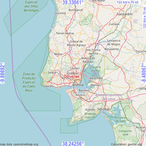
Odivelas GPS coordinates[2]
38° 47' 33.684" North, 9° 11' 1.68" West
| Map corner | latitude | longitude |
|---|---|---|
| Upper-left | 39.33861°, | -9.88692° |
| Center: | 38.79269°, | -9.1838° |
| Lower-right: | 38.24256°, | -8.48067° |
| Map W x H: | 121.9×121.9 km | = 75.7×75.7mi |
| max Lat: | 42.11337° ⇑69.5% North |
| Odivelas: | 38.79269° |
| min Lat: | ⇓30.5% South 32.6448° |
| min Long | Odivelas | max Long |
| -31.17847° | -9.1838° | -6.27308° |
| W 18%⇐ | ⇒82% E |
Elevation
Elevation of Odivelas is 50 m = 164 ft, and this is 127 m = 417 ft below average elevation for this country.
| Max E: |
1008 m = 3307 ft | 70% |
| Avg. | 177 m = 581 ft | |
| Odivelas | 50 m = 164 ft | |
Min E: |
-128 m = -420 ft | 30% |
See also: Odivelas elevation on elevation.city.
Geographical zone
Odivelas is located in North temperate zone (between Tropic of Cancer and the Arctic Circle). Distance of this Northern Tropic circle is 1707.4 km =1060.9 mi to South.| Distance of | km | miles | from Odivelas |
|---|---|---|---|
| North Pole | 5693.7 | 3537.9 | to North |
| Arctic Circle | 3087.8 | 1918.7 | to North |
| Tropic Cancer | 1707.4 | 1060.9 | to South |
| Equator | 4313.3 | 2680.2 | to South |


Nearby cities:
15 places around Odivelas: (largest is in red/bold)
• Alvalade
5.6 km =3.5 mi,  141°
141°
• Amadora
5.9 km =3.7 mi,  223°
223°
• Apelação
5 km =3.1 mi,  62°
62°
• Benfica
4.9 km =3 mi,  199°
199°
• Camarate
5 km =3.1 mi,  75°
75°
• Caneças
4.4 km =2.7 mi,  301°
301°
• Charneca
3.6 km =2.2 mi,  106°
106°
• Famões
2.4 km =1.5 mi,  257°
257°
• Loures
4.5 km =2.8 mi,  17°
17°
• Olival do Basto
1.5 km =0.9 mi,  97°
97°
• Pontinha
3.1 km =1.9 mi,  205°
205°
• Prior Velho
5.4 km =3.4 mi,  91°
91°
• Póvoa de Santo Adrião
1.7 km =1.1 mi, 61°
• Ramada
1.3 km =0.8 mi,  344°
344°
• Unhos
6.3 km =3.9 mi, 61°
Sources, notices
• [Note1] Compared only with cities in Portugal existing in our database
• [Src1] Map data: © OpenStreetMap contributors (CC-BY-SA)
• [Src2] Other city data from geonames.org with taken over terms of usage.
• [Src3] Geographical zone / Annual Mean Temperature by Robert A. Rohde @ Wikipedia
