Charneca geodata
Charneca (Lisbon) is a populated place; located in Portugal in Europe/Lisbon (GMT+0) time zone. With population of 10,509 people, there are 208 cities with bigger population in this country. Compared to other cities in Portugal, 70% of cities are located further ↑North; 80.1% of cities are located further →East and 53.2% of cities have lower elevation than Charneca. Note1


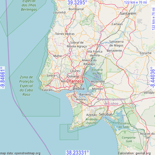
Charneca GPS coordinates[2]
38° 47' 0.636" North, 9° 8' 36.528" West
| Map corner | latitude | longitude |
|---|---|---|
| Upper-left | 39.3295°, | -9.84661° |
| Center: | 38.78351°, | -9.14348° |
| Lower-right: | 38.23331°, | -8.44036° |
| Map W x H: | 121.9×121.9 km | = 75.7×75.7mi |
| max Lat: | 42.11337° ⇑70% North |
| Charneca: | 38.78351° |
| min Lat: | ⇓30% South 32.6448° |
| min Long | Charneca | max Long |
| -31.17847° | -9.14348° | -6.27308° |
| W 19.9%⇐ | ⇒80.1% E |
Elevation
Elevation of Charneca is 123 m = 404 ft, and this is 54 m = 177 ft below average elevation for this country.
| Max E: |
1008 m = 3307 ft | 46.8% |
| Avg. | 177 m = 581 ft | |
| Charneca | 123 m = 404 ft | |
Min E: |
-128 m = -420 ft | 53.2% |
See also: Portugal elevation on elevation.city.
Geographical zone
Charneca is located in North temperate zone (between Tropic of Cancer and the Arctic Circle). Distance of this Northern Tropic circle is 1706.4 km =1060.3 mi to South.| Distance of | km | miles | from Charneca |
|---|---|---|---|
| North Pole | 5694.7 | 3538.5 | to North |
| Arctic Circle | 3088.9 | 1919.4 | to North |
| Tropic Cancer | 1706.4 | 1060.3 | to South |
| Equator | 4312.3 | 2679.5 | to South |


Nearby cities:
15 places around Charneca: (largest is in red/bold)
• Alvalade
3.4 km =2.1 mi,  180°
180°
• Apelação
3.5 km =2.2 mi,  16°
16°
• Bobadela
4.7 km =2.9 mi,  54°
54°
• Camarate
2.6 km =1.6 mi,  30°
30°
• Loures
5.7 km =3.5 mi,  337°
337°
• Moscavide e Portela
3.6 km =2.2 mi,  97°
97°
• Odivelas
3.6 km =2.2 mi,  286°
286°
• Olivais
3.5 km =2.2 mi,  115°
115°
• Olival do Basto
2.1 km =1.3 mi, 292°
• Pontinha
5.2 km =3.2 mi,  250°
250°
• Prior Velho
2.1 km =1.3 mi,  64°
64°
• Póvoa de Santo Adrião
2.7 km =1.7 mi,  312°
312°
• Ramada
4.4 km =2.7 mi,  300°
300°
• Sacavém
3.2 km =2 mi,  72°
72°
• Unhos
4.5 km =2.8 mi, 26°
Sources, notices
• [Note1] Compared only with cities in Portugal existing in our database
• [Src1] Map data: © OpenStreetMap contributors (CC-BY-SA)
• [Src2] Other city data from geonames.org with taken over terms of usage.
• [Src3] Geographical zone / Annual Mean Temperature by Robert A. Rohde @ Wikipedia
