Apelação geodata
Apelação (Lisbon) is a populated place; located in Portugal in Europe/Lisbon (GMT+1) time zone. With population of 7,182 people, there are 315 cities with bigger population in this country. Compared to other cities in Portugal, 68.2% of cities are located further ↑North; 79.5% of cities are located further →East and 56.2% of cities have higher elevation than Apelação. Note1


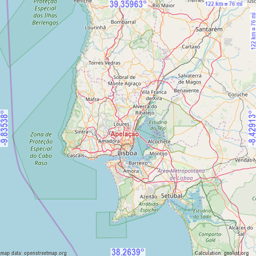
Apelação GPS coordinates[2]
38° 48' 49.932" North, 9° 7' 56.1" West
| Map corner | latitude | longitude |
|---|---|---|
| Upper-left | 39.35963°, | -9.83538° |
| Center: | 38.81387°, | -9.13225° |
| Lower-right: | 38.2639°, | -8.42913° |
| Map W x H: | 121.8×121.8 km | = 75.7×75.7mi |
| max Lat: | 42.11337° ⇑68.2% North |
| Apelação: | 38.81387° |
| min Lat: | ⇓31.8% South 32.6448° |
| min Long | Apelação | max Long |
| -31.17847° | -9.13225° | -6.27308° |
| W 20.5%⇐ | ⇒79.5% E |
Elevation
Elevation of Apelação is 89 m = 292 ft, and this is 88 m = 289 ft below average elevation for this country.
| Max E: |
1008 m = 3307 ft | 56.2% |
| Avg. | 177 m = 581 ft | |
| Apelação | 89 m = 292 ft | |
Min E: |
-128 m = -420 ft | 43.8% |
See also: Portugal elevation on elevation.city.
Geographical zone
Apelação is located in North temperate zone (between Tropic of Cancer and the Arctic Circle). Distance of this Northern Tropic circle is 1709.8 km =1062.4 mi to South.| Distance of | km | miles | from Apelação |
|---|---|---|---|
| North Pole | 5691.4 | 3536.5 | to North |
| Arctic Circle | 3085.5 | 1917.2 | to North |
| Tropic Cancer | 1709.8 | 1062.4 | to South |
| Equator | 4315.7 | 2681.7 | to South |


Nearby cities:
15 places around Apelação: (largest is in red/bold)
• Bobadela
2.9 km =1.8 mi,  103°
103°
• Camarate
1.2 km =0.7 mi,  162°
162°
• Charneca
3.5 km =2.2 mi,  196°
196°
• Loures
3.7 km =2.3 mi,  301°
301°
• Moscavide e Portela
4.6 km =2.9 mi,  145°
145°
• Odivelas
5 km =3.1 mi,  242°
242°
• Olival do Basto
3.9 km =2.4 mi,  228°
228°
• Prior Velho
2.6 km =1.6 mi, 158°
• Póvoa de Santo Adrião
3.4 km =2.1 mi, 242°
• Ramada
4.9 km =3 mi,  256°
256°
• Sacavém
3.2 km =2 mi,  139°
139°
• Santa Iria da Azóia
4.2 km =2.6 mi,  43°
43°
• Santo Antão do Tojal
4.2 km =2.6 mi,  351°
351°
• São João da Talha
3.2 km =2 mi,  70°
70°
• Unhos
1.2 km =0.7 mi,  58°
58°
Sources, notices
• [Note1] Compared only with cities in Portugal existing in our database
• [Src1] Map data: © OpenStreetMap contributors (CC-BY-SA)
• [Src2] Other city data from geonames.org with taken over terms of usage.
• [Src3] Geographical zone / Annual Mean Temperature by Robert A. Rohde @ Wikipedia
