Loures geodata
Loures (Lisbon) is a populated place; located in Portugal in Europe/Lisbon (GMT+1) time zone. With population of 66,231 people, there are 11 cities with bigger population in this country. Compared to other cities in Portugal, 67.9% of cities are located further ↑North; 81.7% of cities are located further →East and 85.5% of cities have higher elevation than Loures. Note1


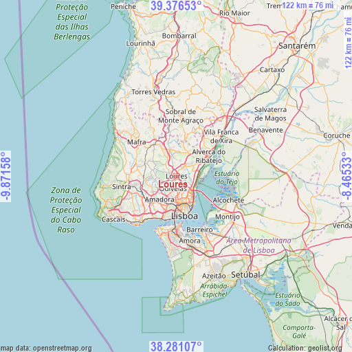
Loures GPS coordinates[2]
38° 49' 51.276" North, 9° 10' 6.42" West
| Map corner | latitude | longitude |
|---|---|---|
| Upper-left | 39.37653°, | -9.87158° |
| Center: | 38.83091°, | -9.16845° |
| Lower-right: | 38.28107°, | -8.46533° |
| Map W x H: | 121.8×121.8 km | = 75.7×75.7mi |
| max Lat: | 42.11337° ⇑67.9% North |
| Loures: | 38.83091° |
| min Lat: | ⇓32.1% South 32.6448° |
| min Long | Loures | max Long |
| -31.17847° | -9.16845° | -6.27308° |
| W 18.3%⇐ | ⇒81.7% E |
Elevation
Elevation of Loures is 23 m = 75 ft, and this is 154 m = 505 ft below average elevation for this country.
| Max E: |
1008 m = 3307 ft | 85.5% |
| Avg. | 177 m = 581 ft | |
| Loures | 23 m = 75 ft | |
Min E: |
-128 m = -420 ft | 14.5% |
See also: Loures elevation on elevation.city.
Geographical zone
Loures is located in North temperate zone (between Tropic of Cancer and the Arctic Circle). Distance of this Northern Tropic circle is 1711.7 km =1063.6 mi to South.| Distance of | km | miles | from Loures |
|---|---|---|---|
| North Pole | 5689.5 | 3535.3 | to North |
| Arctic Circle | 3083.6 | 1916.1 | to North |
| Tropic Cancer | 1711.7 | 1063.6 | to South |
| Equator | 4317.6 | 2682.8 | to South |


Nearby cities:
15 places around Loures: (largest is in red/bold)
• Apelação
3.7 km =2.3 mi,  121°
121°
• Bobadela
6.5 km =4 mi,  113°
113°
• Camarate
4.6 km =2.9 mi,  130°
130°
• Caneças
5.4 km =3.4 mi,  248°
248°
• Charneca
5.7 km =3.5 mi,  157°
157°
• Famões
6 km =3.7 mi,  217°
217°
• Odivelas
4.5 km =2.8 mi,  197°
197°
• Olival do Basto
4.5 km =2.8 mi,  177°
177°
• Prior Velho
6 km =3.7 mi,  136°
136°
• Póvoa de Santo Adrião
3.4 km =2.1 mi, 177°
• Ramada
3.5 km =2.2 mi,  208°
208°
• Santa Iria da Azóia
6.1 km =3.8 mi,  79°
79°
• Santo Antão do Tojal
3.4 km =2.1 mi,  47°
47°
• São João da Talha
6.2 km =3.9 mi,  97°
97°
• Unhos
4.4 km =2.7 mi, 106°
Sources, notices
• [Note1] Compared only with cities in Portugal existing in our database
• [Src1] Map data: © OpenStreetMap contributors (CC-BY-SA)
• [Src2] Other city data from geonames.org with taken over terms of usage.
• [Src3] Geographical zone / Annual Mean Temperature by Robert A. Rohde @ Wikipedia
