Évora geodata
Évora is a seat of a first-order administrative division; located in Portugal in Europe/Lisbon (GMT+1) time zone. With population of 55,620 people, there are 13 cities with bigger population in this country. Compared to other cities in Portugal, 79.9% of cities are located further ↑North; 82.4% of cities are located further ←West and 78.6% of cities have lower elevation than Évora. Note1


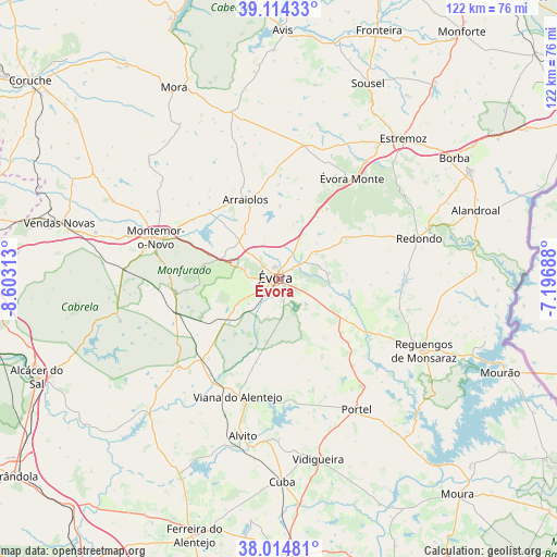
Évora GPS coordinates[2]
38° 34' 0.012" North, 7° 54' 0" West
| Map corner | latitude | longitude |
|---|---|---|
| Upper-left | 39.11433°, | -8.60313° |
| Center: | 38.56667°, | -7.9° |
| Lower-right: | 38.01481°, | -7.19688° |
| Map W x H: | 122.3×122.3 km | = 76×76mi |
| max Lat: | 42.11337° ⇑79.9% North |
| Évora: | 38.56667° |
| min Lat: | ⇓20.1% South 32.6448° |
| min Long | Évora | max Long |
| -31.17847° | -7.9° | -6.27308° |
| W 82.4%⇐ | ⇒17.6% E |
Elevation
Elevation of Évora is 269 m = 883 ft, and this is 92 m = 302 ft above average elevation for this country.
| Max E: |
1008 m = 3307 ft | 21.4% |
| Évora | 269 m 883 ft | |
| Avg. | 177 m = 581 ft | |
Min E: |
-128 m = -420 ft | 78.6% |
See also: Évora elevation on elevation.city.
Geographical zone
Évora is located in North temperate zone (between Tropic of Cancer and the Arctic Circle). Distance of this Northern Tropic circle is 1682.3 km =1045.3 mi to South.| Distance of | km | miles | from Évora |
|---|---|---|---|
| North Pole | 5718.9 | 3553.6 | to North |
| Arctic Circle | 3113 | 1934.3 | to North |
| Tropic Cancer | 1682.3 | 1045.3 | to South |
| Equator | 4288.2 | 2664.6 | to South |


Nearby cities:
15 places around Évora: (largest is in red/bold)
• Alandroal
45.7 km =28.4 mi,  70°
70°
• Alvito
35.4 km =22 mi,  193°
193°
• Arraiolos
18.9 km =11.7 mi,  337°
337°
• Borba
46.9 km =29.1 mi,  55°
55°
• Cuba
44.6 km =27.7 mi,  179°
179°
• Estremoz
41.2 km =25.6 mi,  41°
41°
• Faro do Alentejo
46.6 km =29 mi, 184°
• Montemor-o-Novo
28.8 km =17.9 mi,  288°
288°
• Mora
47.8 km =29.7 mi,  331°
331°
• Portel
33.6 km =20.9 mi,  149°
149°
• Redondo
32 km =19.9 mi, 73°
• Reguengos de Monsaraz
35.4 km =22 mi,  116°
116°
• Viana do Alentejo
27.4 km =17 mi,  199°
199°
• Vidigueira
40.6 km =25.2 mi,  167°
167°
• Vila Viçosa
48 km =29.8 mi, 60°
Sources, notices
• [Note1] Compared only with cities in Portugal existing in our database
• [Src1] Map data: © OpenStreetMap contributors (CC-BY-SA)
• [Src2] Other city data from geonames.org with taken over terms of usage.
• [Src3] Geographical zone / Annual Mean Temperature by Robert A. Rohde @ Wikipedia
