Golegã geodata
Golegã (Santarém) is a seat of a second-order administrative division; located in Portugal in Europe/Lisbon (GMT+1) time zone. With population of 3,830 people, there are 536 cities with bigger population in this country. Compared to other cities in Portugal, 56.1% of cities are located further ↑North; 55.2% of cities are located further ←West and 84% of cities have higher elevation than Golegã. Note1


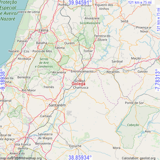
Golegã GPS coordinates[2]
39° 24' 17.064" North, 8° 29' 10.5" West
| Map corner | latitude | longitude |
|---|---|---|
| Upper-left | 39.94591°, | -9.18938° |
| Center: | 39.40474°, | -8.48625° |
| Lower-right: | 38.85934°, | -7.78313° |
| Map W x H: | 120.8×120.8 km | = 75.1×75.1mi |
| max Lat: | 42.11337° ⇑56.1% North |
| Golegã: | 39.40474° |
| min Lat: | ⇓43.9% South 32.6448° |
| min Long | Golegã | max Long |
| -31.17847° | -8.48625° | -6.27308° |
| W 55.2%⇐ | ⇒44.8% E |
Elevation
Elevation of Golegã is 25 m = 82 ft, and this is 152 m = 499 ft below average elevation for this country.
| Max E: |
1008 m = 3307 ft | 84% |
| Avg. | 177 m = 581 ft | |
| Golegã | 25 m = 82 ft | |
Min E: |
-128 m = -420 ft | 16% |
See also: Portugal elevation on elevation.city.
Geographical zone
Golegã is located in North temperate zone (between Tropic of Cancer and the Arctic Circle). Distance of this Northern Tropic circle is 1775.5 km =1103.2 mi to South.| Distance of | km | miles | from Golegã |
|---|---|---|---|
| North Pole | 5625.7 | 3495.6 | to North |
| Arctic Circle | 3019.8 | 1876.4 | to North |
| Tropic Cancer | 1775.5 | 1103.2 | to South |
| Equator | 4381.4 | 2722.5 | to South |


Nearby cities:
15 places around Golegã: (largest is in red/bold)
• Alcanena
16.8 km =10.4 mi,  291°
291°
• Azinhaga
7.3 km =4.5 mi,  211°
211°
• Constância
15.2 km =9.4 mi,  57°
57°
• Entroncamento
7.1 km =4.4 mi,  13°
13°
• Moitas Venda
17.9 km =11.1 mi,  303°
303°
• Montalvo
18.2 km =11.3 mi, 61°
• Paialvo
17.8 km =11.1 mi,  4°
4°
• Pinheiro Grande
4.7 km =2.9 mi,  107°
107°
• Praia do Ribatejo
13.6 km =8.5 mi, 59°
• Riachos
5.1 km =3.2 mi,  331°
331°
• Santa Margarida da Coutada
15.4 km =9.6 mi,  70°
70°
• São Vicente do Paul
13.2 km =8.2 mi,  242°
242°
• Torres Novas
9.3 km =5.8 mi, 328°
• Vale de Figueira
16.5 km =10.3 mi,  228°
228°
• Vila Nova da Barquinha
7.6 km =4.7 mi,  34°
34°
Sources, notices
• [Note1] Compared only with cities in Portugal existing in our database
• [Src1] Map data: © OpenStreetMap contributors (CC-BY-SA)
• [Src2] Other city data from geonames.org with taken over terms of usage.
• [Src3] Geographical zone / Annual Mean Temperature by Robert A. Rohde @ Wikipedia
