São Vicente do Paul geodata
São Vicente do Paul (Santarém) is a populated place; located in Portugal in Europe/Lisbon (GMT+1) time zone. With population of 2,917 people, there are 592 cities with bigger population in this country. Compared to other cities in Portugal, 57.5% of cities are located further ↑North; 55.2% of cities are located further →East and 87.7% of cities have higher elevation than São Vicente do Paul. Note1


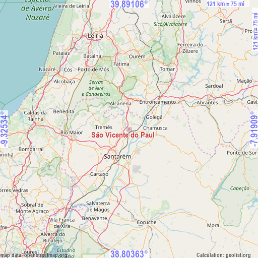
São Vicente do Paul GPS coordinates[2]
39° 20' 58.056" North, 8° 37' 19.956" West
| Map corner | latitude | longitude |
|---|---|---|
| Upper-left | 39.89106°, | -9.32534° |
| Center: | 39.34946°, | -8.62221° |
| Lower-right: | 38.80363°, | -7.91909° |
| Map W x H: | 120.9×120.9 km | = 75.1×75.1mi |
| max Lat: | 42.11337° ⇑57.5% North |
| São Vicente do Paul: | 39.34946° |
| min Lat: | ⇓42.5% South 32.6448° |
| min Long | São Vicente do | max Long |
| -31.17847° | -8.62221° | -6.27308° |
| W 44.8%⇐ | ⇒55.2% E |
Elevation
Elevation of São Vicente do Paul is 20 m = 66 ft, and this is 157 m = 515 ft below average elevation for this country.
| Max E: |
1008 m = 3307 ft | 87.7% |
| Avg. | 177 m = 581 ft | |
| São Vicente do Paul | 20 m = 66 ft | |
Min E: |
-128 m = -420 ft | 12.3% |
See also: Portugal elevation on elevation.city.
Geographical zone
São Vicente do Paul is located in North temperate zone (between Tropic of Cancer and the Arctic Circle). Distance of this Northern Tropic circle is 1769.3 km =1099.4 mi to South.| Distance of | km | miles | from São Vicente do Paul |
|---|---|---|---|
| North Pole | 5631.8 | 3499.4 | to North |
| Arctic Circle | 3025.9 | 1880.2 | to North |
| Tropic Cancer | 1769.3 | 1099.4 | to South |
| Equator | 4375.2 | 2718.6 | to South |


Nearby cities:
15 places around São Vicente do Paul: (largest is in red/bold)
• Alcanede
18.6 km =11.6 mi,  293°
293°
• Alcanena
12.8 km =8 mi,  341°
341°
• Alcanhões
6.7 km =4.2 mi,  207°
207°
• Almeirim
15.7 km =9.8 mi,  181°
181°
• Alpiarça
10.8 km =6.7 mi,  161°
161°
• Amiães de Baixo
14.1 km =8.8 mi,  317°
317°
• Azinhaga
7.9 km =4.9 mi,  90°
90°
• Golegã
13.2 km =8.2 mi,  62°
62°
• Moitas Venda
16.3 km =10.1 mi,  348°
348°
• Monsanto
14.7 km =9.1 mi,  328°
328°
• Pinheiro Grande
16.9 km =10.5 mi,  73°
73°
• Riachos
14.1 km =8.8 mi,  41°
41°
• Santarém
13.9 km =8.6 mi,  202°
202°
• Torres Novas
15.6 km =9.7 mi,  25°
25°
• Vale de Figueira
4.9 km =3 mi,  186°
186°
Sources, notices
• [Note1] Compared only with cities in Portugal existing in our database
• [Src1] Map data: © OpenStreetMap contributors (CC-BY-SA)
• [Src2] Other city data from geonames.org with taken over terms of usage.
• [Src3] Geographical zone / Annual Mean Temperature by Robert A. Rohde @ Wikipedia
