Azinhaga geodata
Azinhaga (Santarém) is a populated place; located in Portugal in Europe/Lisbon (GMT+1) time zone. With population of 1,620 people, there are 682 cities with bigger population in this country. Compared to other cities in Portugal, 57.6% of cities are located further ↑North; 52.5% of cities are located further ←West and 88.3% of cities have higher elevation than Azinhaga. Note1


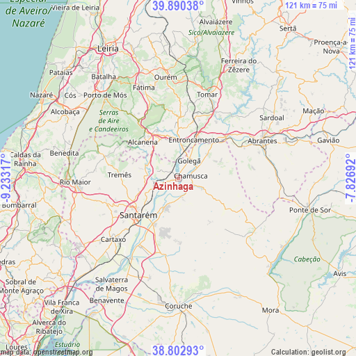
Azinhaga GPS coordinates[2]
39° 20' 55.572" North, 8° 31' 48.18" West
| Map corner | latitude | longitude |
|---|---|---|
| Upper-left | 39.89038°, | -9.23317° |
| Center: | 39.34877°, | -8.53005° |
| Lower-right: | 38.80293°, | -7.82692° |
| Map W x H: | 120.9×120.9 km | = 75.1×75.1mi |
| max Lat: | 42.11337° ⇑57.6% North |
| Azinhaga: | 39.34877° |
| min Lat: | ⇓42.4% South 32.6448° |
| min Long | Azinhaga | max Long |
| -31.17847° | -8.53005° | -6.27308° |
| W 52.5%⇐ | ⇒47.5% E |
Elevation
Elevation of Azinhaga is 19 m = 62 ft, and this is 158 m = 518 ft below average elevation for this country.
| Max E: |
1008 m = 3307 ft | 88.3% |
| Avg. | 177 m = 581 ft | |
| Azinhaga | 19 m = 62 ft | |
Min E: |
-128 m = -420 ft | 11.7% |
See also: Portugal elevation on elevation.city.
Geographical zone
Azinhaga is located in North temperate zone (between Tropic of Cancer and the Arctic Circle). Distance of this Northern Tropic circle is 1769.3 km =1099.4 mi to South.| Distance of | km | miles | from Azinhaga |
|---|---|---|---|
| North Pole | 5631.9 | 3499.5 | to North |
| Arctic Circle | 3026 | 1880.3 | to North |
| Tropic Cancer | 1769.3 | 1099.4 | to South |
| Equator | 4375.2 | 2718.6 | to South |


Nearby cities:
15 places around Azinhaga: (largest is in red/bold)
• Alcanena
17.1 km =10.6 mi,  315°
315°
• Alcanhões
12.5 km =7.8 mi,  242°
242°
• Almeirim
17.7 km =11 mi,  207°
207°
• Alpiarça
11.1 km =6.9 mi,  203°
203°
• Entroncamento
14.2 km =8.8 mi,  22°
22°
• Fazendas de Almeirim
19.6 km =12.2 mi,  189°
189°
• Golegã
7.3 km =4.5 mi,  31°
31°
• Moitas Venda
19.5 km =12.1 mi,  325°
325°
• Pinheiro Grande
9.6 km =6 mi,  59°
59°
• Riachos
10.8 km =6.7 mi,  7°
7°
• Santarém
18.4 km =11.4 mi,  225°
225°
• São Vicente do Paul
7.9 km =4.9 mi,  270°
270°
• Torres Novas
14.2 km =8.8 mi,  355°
355°
• Vale de Figueira
9.7 km =6 mi, 240°
• Vila Nova da Barquinha
14.9 km =9.3 mi, 33°
Sources, notices
• [Note1] Compared only with cities in Portugal existing in our database
• [Src1] Map data: © OpenStreetMap contributors (CC-BY-SA)
• [Src2] Other city data from geonames.org with taken over terms of usage.
• [Src3] Geographical zone / Annual Mean Temperature by Robert A. Rohde @ Wikipedia
