Torres Novas geodata
Torres Novas (Santarém) is a seat of a second-order administrative division; located in Portugal in Europe/Lisbon (GMT+1) time zone. With population of 15,002 people, there are 140 cities with bigger population in this country. Compared to other cities in Portugal, 53.3% of cities are located further ↑North; 51.6% of cities are located further ←West and 65.2% of cities have higher elevation than Torres Novas. Note1
Administrative division(s):
- Level 1: Santarém
- Level 2: Torres Novas
- Level 3: Torres Novas (Salvador)


Torres Novas GPS coordinates[2]
39° 28' 32.916" North, 8° 32' 36.528" West
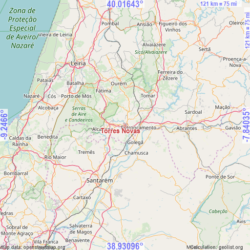
| Map corner | latitude | longitude |
|---|---|---|
| Upper-left | 40.01643°, | -9.2466° |
| Center: | 39.47581°, | -8.54348° |
| Lower-right: | 38.93096°, | -7.84035° |
| Map W x H: | 120.7×120.7 km | = 75×75mi |
| max Lat: | 42.11337° ⇑53.3% North |
| Torres Novas: | 39.47581° |
| min Lat: | ⇓46.7% South 32.6448° |
| min Long | Torres Novas | max Long |
| -31.17847° | -8.54348° | -6.27308° |
| W 51.6%⇐ | ⇒48.4% E |
Elevation
Elevation of Torres Novas is 61 m = 200 ft, and this is 116 m = 381 ft below average elevation for this country.
| Max E: |
1008 m = 3307 ft | 65.2% |
| Avg. | 177 m = 581 ft | |
| Torres Novas | 61 m = 200 ft | |
Min E: |
-128 m = -420 ft | 34.8% |
See also: Portugal elevation on elevation.city.
Geographical zone
Torres Novas is located in North temperate zone (between Tropic of Cancer and the Arctic Circle). Distance of this Northern Tropic circle is 1783.4 km =1108.2 mi to South.| Distance of | km | miles | from Torres Novas |
|---|---|---|---|
| North Pole | 5617.8 | 3490.7 | to North |
| Arctic Circle | 3011.9 | 1871.5 | to North |
| Tropic Cancer | 1783.4 | 1108.2 | to South |
| Equator | 4389.3 | 2727.4 | to South |


Nearby cities:
15 places around Torres Novas: (largest is in red/bold)
• Alcanena
10.9 km =6.8 mi,  260°
260°
• Azinhaga
14.2 km =8.8 mi,  175°
175°
• Entroncamento
6.7 km =4.2 mi,  98°
98°
• Golegã
9.3 km =5.8 mi,  148°
148°
• Madalena
13.5 km =8.4 mi,  38°
38°
• Minde
13.2 km =8.2 mi,  289°
289°
• Mira
16.5 km =10.3 mi,  296°
296°
• Moitas Venda
10.2 km =6.3 mi,  280°
280°
• Monsanto
14.5 km =9 mi, 263°
• Paialvo
11.7 km =7.3 mi,  33°
33°
• Pinheiro Grande
13.2 km =8.2 mi,  134°
134°
• Praia do Ribatejo
16.6 km =10.3 mi,  93°
93°
• Riachos
4.3 km =2.7 mi,  143°
143°
• São Vicente do Paul
15.6 km =9.7 mi,  205°
205°
• Vila Nova da Barquinha
9.4 km =5.8 mi, 100°
Sources, notices
• [Note1] Compared only with cities in Portugal existing in our database
• [Src1] Map data: © OpenStreetMap contributors (CC-BY-SA)
• [Src2] Other city data from geonames.org with taken over terms of usage.
• [Src3] Geographical zone / Annual Mean Temperature by Robert A. Rohde @ Wikipedia
