Riachos geodata
Riachos (Santarém) is a populated place; located in Portugal in Europe/Lisbon (GMT+1) time zone. With population of 5,463 people, there are 395 cities with bigger population in this country. Compared to other cities in Portugal, 55% of cities are located further ↑North; 54% of cities are located further ←West and 73.9% of cities have higher elevation than Riachos. Note1


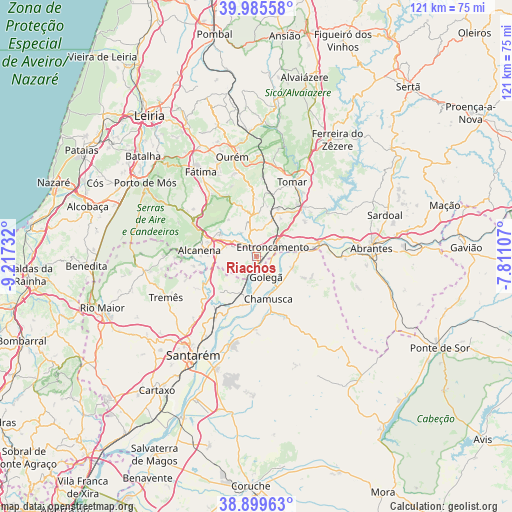
Riachos GPS coordinates[2]
39° 26' 40.992" North, 8° 30' 51.12" West
| Map corner | latitude | longitude |
|---|---|---|
| Upper-left | 39.98558°, | -9.21732° |
| Center: | 39.44472°, | -8.5142° |
| Lower-right: | 38.89963°, | -7.81107° |
| Map W x H: | 120.7×120.7 km | = 75×75mi |
| max Lat: | 42.11337° ⇑55% North |
| Riachos: | 39.44472° |
| min Lat: | ⇓45% South 32.6448° |
| min Long | Riachos | max Long |
| -31.17847° | -8.5142° | -6.27308° |
| W 54%⇐ | ⇒46% E |
Elevation
Elevation of Riachos is 42 m = 138 ft, and this is 135 m = 443 ft below average elevation for this country.
| Max E: |
1008 m = 3307 ft | 73.9% |
| Avg. | 177 m = 581 ft | |
| Riachos | 42 m = 138 ft | |
Min E: |
-128 m = -420 ft | 26.1% |
See also: Portugal elevation on elevation.city.
Geographical zone
Riachos is located in North temperate zone (between Tropic of Cancer and the Arctic Circle). Distance of this Northern Tropic circle is 1779.9 km =1106 mi to South.| Distance of | km | miles | from Riachos |
|---|---|---|---|
| North Pole | 5621.2 | 3492.9 | to North |
| Arctic Circle | 3015.3 | 1873.6 | to North |
| Tropic Cancer | 1779.9 | 1106 | to South |
| Equator | 4385.8 | 2725.2 | to South |


Nearby cities:
15 places around Riachos: (largest is in red/bold)
• Alcanena
13.4 km =8.3 mi,  276°
276°
• Azinhaga
10.8 km =6.7 mi,  187°
187°
• Constância
15.7 km =9.8 mi,  76°
76°
• Entroncamento
4.8 km =3 mi,  59°
59°
• Golegã
5.1 km =3.2 mi,  151°
151°
• Madalena
15.2 km =9.4 mi,  22°
22°
• Minde
16.9 km =10.5 mi,  298°
298°
• Moitas Venda
13.6 km =8.5 mi,  293°
293°
• Paialvo
13.8 km =8.6 mi, 16°
• Pinheiro Grande
9 km =5.6 mi,  130°
130°
• Praia do Ribatejo
14.3 km =8.9 mi, 80°
• Santa Margarida da Coutada
17 km =10.6 mi,  88°
88°
• São Vicente do Paul
14.1 km =8.8 mi,  221°
221°
• Torres Novas
4.3 km =2.7 mi,  323°
323°
• Vila Nova da Barquinha
7 km =4.3 mi, 75°
Sources, notices
• [Note1] Compared only with cities in Portugal existing in our database
• [Src1] Map data: © OpenStreetMap contributors (CC-BY-SA)
• [Src2] Other city data from geonames.org with taken over terms of usage.
• [Src3] Geographical zone / Annual Mean Temperature by Robert A. Rohde @ Wikipedia
