Fátima geodata
Fátima (Santarém) is a populated place; located in Portugal in Europe/Lisbon (GMT+1) time zone. With population of 11,798 people, there are 174 cities with bigger population in this country. Compared to other cities in Portugal, 50.1% of cities are located further ↑North; 59.2% of cities are located further →East and 84.8% of cities have lower elevation than Fátima. Note1


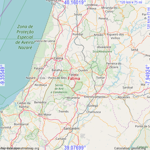
Fátima GPS coordinates[2]
39° 37' 14.556" North, 8° 39' 8.532" West
| Map corner | latitude | longitude |
|---|---|---|
| Upper-left | 40.16019°, | -9.35549° |
| Center: | 39.62071°, | -8.65237° |
| Lower-right: | 39.07699°, | -7.94924° |
| Map W x H: | 120.4×120.4 km | = 74.8×74.8mi |
| max Lat: | 42.11337° ⇑50.1% North |
| Fátima: | 39.62071° |
| min Lat: | ⇓49.9% South 32.6448° |
| min Long | Fátima | max Long |
| -31.17847° | -8.65237° | -6.27308° |
| W 40.8%⇐ | ⇒59.2% E |
Elevation
Elevation of Fátima is 358 m = 1175 ft, and this is 181 m = 594 ft above average elevation for this country.
| Max E: |
1008 m = 3307 ft | 15.2% |
| Fátima | 358 m 1175 ft | |
| Avg. | 177 m = 581 ft | |
Min E: |
-128 m = -420 ft | 84.8% |
See also: Portugal elevation on elevation.city.
Geographical zone
Fátima is located in North temperate zone (between Tropic of Cancer and the Arctic Circle). Distance of this Northern Tropic circle is 1799.5 km =1118.2 mi to South.| Distance of | km | miles | from Fátima |
|---|---|---|---|
| North Pole | 5601.7 | 3480.7 | to North |
| Arctic Circle | 2995.8 | 1861.5 | to North |
| Tropic Cancer | 1799.5 | 1118.2 | to South |
| Equator | 4405.4 | 2737.4 | to South |


Nearby cities:
15 places around Fátima: (largest is in red/bold)
• Alcanena
18 km =11.2 mi,  184°
184°
• Batalha
15.4 km =9.6 mi,  286°
286°
• Caranguejeira
14.7 km =9.1 mi,  341°
341°
• Leiria
19 km =11.8 mi,  315°
315°
• Madalena
18.5 km =11.5 mi,  107°
107°
• Minde
12 km =7.5 mi,  194°
194°
• Mira
10.2 km =6.3 mi,  211°
211°
• Moitas Venda
14.2 km =8.8 mi, 182°
• Monsanto
18.4 km =11.4 mi,  196°
196°
• Ourém
5.7 km =3.5 mi,  65°
65°
• Paialvo
17 km =10.6 mi, 111°
• Porto de Mós
14.4 km =8.9 mi,  261°
261°
• Santa Catarina da Serra
7.2 km =4.5 mi, 335°
• Tomar
20.9 km =13 mi,  95°
95°
• Torres Novas
18.6 km =11.6 mi,  149°
149°
Sources, notices
• [Note1] Compared only with cities in Portugal existing in our database
• [Src1] Map data: © OpenStreetMap contributors (CC-BY-SA)
• [Src2] Other city data from geonames.org with taken over terms of usage.
• [Src3] Geographical zone / Annual Mean Temperature by Robert A. Rohde @ Wikipedia
