Ourém geodata
Ourém (Santarém) is a seat of a second-order administrative division; located in Portugal in Europe/Lisbon (GMT+1) time zone. With population of 12,729 people, there are 160 cities with bigger population in this country. Compared to other cities in Portugal, 50.1% of cities are located further ↓South; 53.1% of cities are located further →East and 82.5% of cities have lower elevation than Ourém. Note1
Administrative division(s):
- Level 1: Santarém
- Level 2: Ourém
- Level 3: Nossa Senhora das Misericórdias


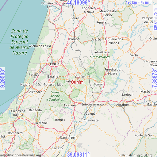
Ourém GPS coordinates[2]
39° 38' 30.012" North, 8° 35' 30.84" West
| Map corner | latitude | longitude |
|---|---|---|
| Upper-left | 40.18099°, | -9.29503° |
| Center: | 39.64167°, | -8.5919° |
| Lower-right: | 39.09811°, | -7.88878° |
| Map W x H: | 120.4×120.4 km | = 74.8×74.8mi |
| max Lat: | 42.11337° ⇑49.9% North |
| Ourém: | 39.64167° |
| min Lat: | ⇓50.1% South 32.6448° |
| min Long | Ourém | max Long |
| -31.17847° | -8.5919° | -6.27308° |
| W 46.9%⇐ | ⇒53.1% E |
Elevation
Elevation of Ourém is 315 m = 1033 ft, and this is 138 m = 453 ft above average elevation for this country.
| Max E: |
1008 m = 3307 ft | 17.5% |
| Ourém | 315 m 1033 ft | |
| Avg. | 177 m = 581 ft | |
Min E: |
-128 m = -420 ft | 82.5% |
See also: Portugal elevation on elevation.city.
Geographical zone
Ourém is located in North temperate zone (between Tropic of Cancer and the Arctic Circle). Distance of this Northern Tropic circle is 1801.8 km =1119.6 mi to South.| Distance of | km | miles | from Ourém |
|---|---|---|---|
| North Pole | 5599.3 | 3479.2 | to North |
| Arctic Circle | 2993.4 | 1860 | to North |
| Tropic Cancer | 1801.8 | 1119.6 | to South |
| Equator | 4407.7 | 2738.8 | to South |


Nearby cities:
15 places around Ourém: (largest is in red/bold)
• Alcanena
21.4 km =13.3 mi,  198°
198°
• Batalha
20 km =12.4 mi,  275°
275°
• Caranguejeira
15.3 km =9.5 mi,  319°
319°
• Entroncamento
22.2 km =13.8 mi,  151°
151°
• Fátima
5.7 km =3.5 mi,  245°
245°
• Leiria
21.6 km =13.4 mi,  301°
301°
• Madalena
14.7 km =9.1 mi,  122°
122°
• Minde
16.2 km =10.1 mi,  210°
210°
• Mira
15.2 km =9.4 mi,  223°
223°
• Moitas Venda
17.6 km =10.9 mi, 199°
• Paialvo
13.7 km =8.5 mi,  129°
129°
• Porto de Mós
19.9 km =12.4 mi,  257°
257°
• Santa Catarina da Serra
9.2 km =5.7 mi, 297°
• Tomar
16.3 km =10.1 mi,  105°
105°
• Torres Novas
18.9 km =11.7 mi,  167°
167°
Sources, notices
• [Note1] Compared only with cities in Portugal existing in our database
• [Src1] Map data: © OpenStreetMap contributors (CC-BY-SA)
• [Src2] Other city data from geonames.org with taken over terms of usage.
• [Src3] Geographical zone / Annual Mean Temperature by Robert A. Rohde @ Wikipedia
