Mira geodata
Mira (Leiria) is a populated place; located in Portugal in Europe/Lisbon (GMT+1) time zone. With population of 3,775 people, there are 541 cities with bigger population in this country. Compared to other cities in Portugal, 51.5% of cities are located further ↑North; 63.6% of cities are located further →East and 77.3% of cities have lower elevation than Mira. Note1


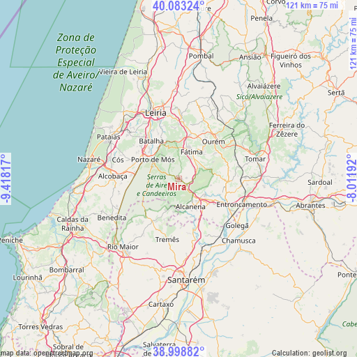
Mira GPS coordinates[2]
39° 32' 35.34" North, 8° 42' 54.18" West
| Map corner | latitude | longitude |
|---|---|---|
| Upper-left | 40.08324°, | -9.41817° |
| Center: | 39.54315°, | -8.71505° |
| Lower-right: | 38.99882°, | -8.01192° |
| Map W x H: | 120.6×120.6 km | = 74.9×74.9mi |
| max Lat: | 42.11337° ⇑51.5% North |
| Mira: | 39.54315° |
| min Lat: | ⇓48.5% South 32.6448° |
| min Long | Mira | max Long |
| -31.17847° | -8.71505° | -6.27308° |
| W 36.4%⇐ | ⇒63.6% E |
Elevation
Elevation of Mira is 255 m = 837 ft, and this is 78 m = 256 ft above average elevation for this country.
| Max E: |
1008 m = 3307 ft | 22.7% |
| Mira | 255 m 837 ft | |
| Avg. | 177 m = 581 ft | |
Min E: |
-128 m = -420 ft | 77.3% |
See also: Portugal elevation on elevation.city.
Geographical zone
Mira is located in North temperate zone (between Tropic of Cancer and the Arctic Circle). Distance of this Northern Tropic circle is 1790.9 km =1112.8 mi to South.| Distance of | km | miles | from Mira |
|---|---|---|---|
| North Pole | 5610.3 | 3486.1 | to North |
| Arctic Circle | 3004.4 | 1866.8 | to North |
| Tropic Cancer | 1790.9 | 1112.8 | to South |
| Equator | 4396.8 | 2732 | to South |


Nearby cities:
15 places around Mira: (largest is in red/bold)
• Alcanede
16.9 km =10.5 mi,  212°
212°
• Alcanena
10.2 km =6.3 mi,  157°
157°
• Aljubarrota
18.6 km =11.6 mi,  278°
278°
• Amiães de Baixo
11.3 km =7 mi,  188°
188°
• Batalha
16.1 km =10 mi,  324°
324°
• Fátima
10.2 km =6.3 mi,  31°
31°
• Minde
3.8 km =2.4 mi,  142°
142°
• Moitas Venda
7.3 km =4.5 mi, 140°
• Monsanto
9 km =5.6 mi,  178°
178°
• Ourém
15.2 km =9.4 mi,  43°
43°
• Paialvo
21.3 km =13.2 mi,  83°
83°
• Porto de Mós
11 km =6.8 mi,  306°
306°
• Riachos
20.4 km =12.7 mi,  122°
122°
• Santa Catarina da Serra
15.4 km =9.6 mi,  9°
9°
• Torres Novas
16.5 km =10.3 mi, 116°
Sources, notices
• [Note1] Compared only with cities in Portugal existing in our database
• [Src1] Map data: © OpenStreetMap contributors (CC-BY-SA)
• [Src2] Other city data from geonames.org with taken over terms of usage.
• [Src3] Geographical zone / Annual Mean Temperature by Robert A. Rohde @ Wikipedia
