Alcanede geodata
Alcanede (Santarém) is a populated place; located in Portugal in Europe/Lisbon (GMT+1) time zone. With population of 5,020 people, there are 421 cities with bigger population in this country. Compared to other cities in Portugal, 55.9% of cities are located further ↑North; 69.1% of cities are located further →East and 56.2% of cities have higher elevation than Alcanede. Note1


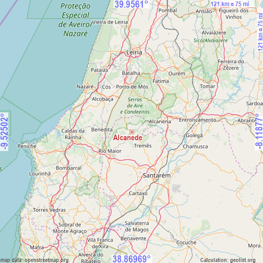
Alcanede GPS coordinates[2]
39° 24' 54.036" North, 8° 49' 18.804" West
| Map corner | latitude | longitude |
|---|---|---|
| Upper-left | 39.9561°, | -9.52502° |
| Center: | 39.41501°, | -8.82189° |
| Lower-right: | 38.86969°, | -8.11877° |
| Map W x H: | 120.8×120.8 km | = 75.1×75.1mi |
| max Lat: | 42.11337° ⇑55.9% North |
| Alcanede: | 39.41501° |
| min Lat: | ⇓44.1% South 32.6448° |
| min Long | Alcanede | max Long |
| -31.17847° | -8.82189° | -6.27308° |
| W 30.9%⇐ | ⇒69.1% E |
Elevation
Elevation of Alcanede is 89 m = 292 ft, and this is 88 m = 289 ft below average elevation for this country.
| Max E: |
1008 m = 3307 ft | 56.2% |
| Avg. | 177 m = 581 ft | |
| Alcanede | 89 m = 292 ft | |
Min E: |
-128 m = -420 ft | 43.8% |
See also: Portugal elevation on elevation.city.
Geographical zone
Alcanede is located in North temperate zone (between Tropic of Cancer and the Arctic Circle). Distance of this Northern Tropic circle is 1776.6 km =1103.9 mi to South.| Distance of | km | miles | from Alcanede |
|---|---|---|---|
| North Pole | 5624.5 | 3494.9 | to North |
| Arctic Circle | 3018.6 | 1875.7 | to North |
| Tropic Cancer | 1776.6 | 1103.9 | to South |
| Equator | 4382.5 | 2723.2 | to South |


Nearby cities:
15 places around Alcanede: (largest is in red/bold)
• Alcanena
14 km =8.7 mi,  69°
69°
• Alcanhões
19.3 km =12 mi,  133°
133°
• Alcobaça
20.3 km =12.6 mi,  318°
318°
• Aljubarrota
19.3 km =12 mi,  331°
331°
• Alvorninha
18.8 km =11.7 mi,  258°
258°
• Amiães de Baixo
8.2 km =5.1 mi, 67°
• Benedita
12.8 km =8 mi,  274°
274°
• Minde
16.1 km =10 mi,  45°
45°
• Mira
16.9 km =10.5 mi,  32°
32°
• Moitas Venda
16.3 km =10.1 mi,  58°
58°
• Monsanto
10.8 km =6.7 mi, 61°
• Rio Maior
13.3 km =8.3 mi,  229°
229°
• São Vicente do Paul
18.6 km =11.6 mi,  113°
113°
• Turquel
14.4 km =8.9 mi,  292°
292°
• Vidais
20.2 km =12.6 mi, 255°
Sources, notices
• [Note1] Compared only with cities in Portugal existing in our database
• [Src1] Map data: © OpenStreetMap contributors (CC-BY-SA)
• [Src2] Other city data from geonames.org with taken over terms of usage.
• [Src3] Geographical zone / Annual Mean Temperature by Robert A. Rohde @ Wikipedia
