Famalicão geodata
Famalicão (Leiria) is a populated place; located in Portugal in Europe/Lisbon (GMT+1) time zone. With population of 1,740 people, there are 670 cities with bigger population in this country. Compared to other cities in Portugal, 51.7% of cities are located further ↑North; 76.8% of cities are located further →East and 78.1% of cities have higher elevation than Famalicão. Note1


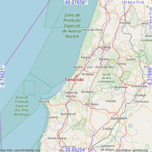
Famalicão GPS coordinates[2]
39° 32' 11.112" North, 9° 4' 59.088" West
| Map corner | latitude | longitude |
|---|---|---|
| Upper-left | 40.07656°, | -9.78621° |
| Center: | 39.53642°, | -9.08308° |
| Lower-right: | 38.99204°, | -8.37996° |
| Map W x H: | 120.6×120.6 km | = 74.9×74.9mi |
| max Lat: | 42.11337° ⇑51.7% North |
| Famalicão: | 39.53642° |
| min Lat: | ⇓48.3% South 32.6448° |
| min Long | Famalicão | max Long |
| -31.17847° | -9.08308° | -6.27308° |
| W 23.2%⇐ | ⇒76.8% E |
Elevation
Elevation of Famalicão is 35 m = 115 ft, and this is 142 m = 466 ft below average elevation for this country.
| Max E: |
1008 m = 3307 ft | 78.1% |
| Avg. | 177 m = 581 ft | |
| Famalicão | 35 m = 115 ft | |
Min E: |
-128 m = -420 ft | 21.9% |
See also: Portugal elevation on elevation.city.
Geographical zone
Famalicão is located in North temperate zone (between Tropic of Cancer and the Arctic Circle). Distance of this Northern Tropic circle is 1790.1 km =1112.3 mi to South.| Distance of | km | miles | from Famalicão |
|---|---|---|---|
| North Pole | 5611 | 3486.5 | to North |
| Arctic Circle | 3005.1 | 1867.3 | to North |
| Tropic Cancer | 1790.1 | 1112.3 | to South |
| Equator | 4396 | 2731.5 | to South |


Nearby cities:
15 places around Famalicão: (largest is in red/bold)
• Alcobaça
9.2 km =5.7 mi,  79°
79°
• Alfeizerão
4.4 km =2.7 mi,  203°
203°
• Aljubarrota
13.6 km =8.5 mi, 75°
• Benedita
15.8 km =9.8 mi,  141°
141°
• Caldas da Rainha
15.5 km =9.6 mi, 197°
• Cela
4.2 km =2.6 mi, 83°
• Foz do Arelho
15.8 km =9.8 mi,  225°
225°
• Nazaré
7.5 km =4.7 mi,  9°
9°
• Salir de Matos
11.7 km =7.3 mi,  184°
184°
• Salir do Porto
7.8 km =4.8 mi, 233°
• Serra do Bouro
12.2 km =7.6 mi,  221°
221°
• São Martinho do Porto
4.8 km =3 mi,  239°
239°
• Turquel
12.1 km =7.5 mi,  131°
131°
• Valado de Frades
7.4 km =4.6 mi,  44°
44°
• Vestiaria
7.5 km =4.7 mi, 76°
Sources, notices
• [Note1] Compared only with cities in Portugal existing in our database
• [Src1] Map data: © OpenStreetMap contributors (CC-BY-SA)
• [Src2] Other city data from geonames.org with taken over terms of usage.
• [Src3] Geographical zone / Annual Mean Temperature by Robert A. Rohde @ Wikipedia
