Nazaré geodata
Nazaré (Leiria) is a seat of a second-order administrative division; located in Portugal in Europe/Lisbon (GMT+1) time zone. With population of 8,993 people, there are 247 cities with bigger population in this country. Compared to other cities in Portugal, 50.3% of cities are located further ↑North; 76.4% of cities are located further →East and 72.1% of cities have higher elevation than Nazaré. Note1


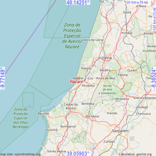
Nazaré GPS coordinates[2]
39° 36' 10.404" North, 9° 4' 6.096" West
| Map corner | latitude | longitude |
|---|---|---|
| Upper-left | 40.14251°, | -9.77149° |
| Center: | 39.60289°, | -9.06836° |
| Lower-right: | 39.05903°, | -8.36524° |
| Map W x H: | 120.5×120.5 km | = 74.9×74.9mi |
| max Lat: | 42.11337° ⇑50.3% North |
| Nazaré: | 39.60289° |
| min Lat: | ⇓49.7% South 32.6448° |
| min Long | Nazaré | max Long |
| -31.17847° | -9.06836° | -6.27308° |
| W 23.6%⇐ | ⇒76.4% E |
Elevation
Elevation of Nazaré is 46 m = 151 ft, and this is 131 m = 430 ft below average elevation for this country.
| Max E: |
1008 m = 3307 ft | 72.1% |
| Avg. | 177 m = 581 ft | |
| Nazaré | 46 m = 151 ft | |
Min E: |
-128 m = -420 ft | 27.9% |
See also: Portugal elevation on elevation.city.
Geographical zone
Nazaré is located in North temperate zone (between Tropic of Cancer and the Arctic Circle). Distance of this Northern Tropic circle is 1797.5 km =1116.9 mi to South.| Distance of | km | miles | from Nazaré |
|---|---|---|---|
| North Pole | 5603.6 | 3481.9 | to North |
| Arctic Circle | 2997.7 | 1862.7 | to North |
| Tropic Cancer | 1797.5 | 1116.9 | to South |
| Equator | 4403.4 | 2736.1 | to South |


Nearby cities:
15 places around Nazaré: (largest is in red/bold)
• Alcobaça
9.6 km =6 mi,  125°
125°
• Alfeizerão
11.9 km =7.4 mi,  194°
194°
• Aljubarrota
12.6 km =7.8 mi,  108°
108°
• Cela
7.5 km =4.7 mi,  157°
157°
• Famalicão
7.5 km =4.7 mi, 189°
• Maceira
17.7 km =11 mi,  57°
57°
• Marinha Grande
19.9 km =12.4 mi,  35°
35°
• Pataias
9.7 km =6 mi, 39°
• Salir de Matos
19.2 km =11.9 mi, 186°
• Salir do Porto
14.1 km =8.8 mi,  212°
212°
• Serra do Bouro
19 km =11.8 mi, 209°
• São Martinho do Porto
11.2 km =7 mi, 208°
• Turquel
17.3 km =10.7 mi,  153°
153°
• Valado de Frades
4.4 km =2.7 mi,  117°
117°
• Vestiaria
8.2 km =5.1 mi, 132°
Sources, notices
• [Note1] Compared only with cities in Portugal existing in our database
• [Src1] Map data: © OpenStreetMap contributors (CC-BY-SA)
• [Src2] Other city data from geonames.org with taken over terms of usage.
• [Src3] Geographical zone / Annual Mean Temperature by Robert A. Rohde @ Wikipedia
