Vestiaria geodata
Vestiaria (Leiria) is a populated place; located in Portugal in Europe/Lisbon (GMT+1) time zone. With population of 1,258 people, there are 720 cities with bigger population in this country. Compared to other cities in Portugal, 51.2% of cities are located further ↑North; 73.9% of cities are located further →East and 63% of cities have lower elevation than Vestiaria. Note1


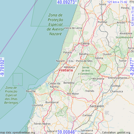
Vestiaria GPS coordinates[2]
39° 33' 9.756" North, 8° 59' 52.44" West
| Map corner | latitude | longitude |
|---|---|---|
| Upper-left | 40.09273°, | -9.70102° |
| Center: | 39.55271°, | -8.9979° |
| Lower-right: | 39.00846°, | -8.29477° |
| Map W x H: | 120.6×120.6 km | = 74.9×74.9mi |
| max Lat: | 42.11337° ⇑51.2% North |
| Vestiaria: | 39.55271° |
| min Lat: | ⇓48.8% South 32.6448° |
| min Long | Vestiaria | max Long |
| -31.17847° | -8.9979° | -6.27308° |
| W 26.1%⇐ | ⇒73.9% E |
Elevation
Elevation of Vestiaria is 168 m = 551 ft, and this is 9 m = 30 ft below average elevation for this country.
| Max E: |
1008 m = 3307 ft | 37% |
| Avg. | 177 m = 581 ft | |
| Vestiaria | 168 m = 551 ft | |
Min E: |
-128 m = -420 ft | 63% |
See also: Portugal elevation on elevation.city.
Geographical zone
Vestiaria is located in North temperate zone (between Tropic of Cancer and the Arctic Circle). Distance of this Northern Tropic circle is 1791.9 km =1113.4 mi to South.| Distance of | km | miles | from Vestiaria |
|---|---|---|---|
| North Pole | 5609.2 | 3485.4 | to North |
| Arctic Circle | 3003.3 | 1866.2 | to North |
| Tropic Cancer | 1791.9 | 1113.4 | to South |
| Equator | 4397.8 | 2732.7 | to South |


Nearby cities:
15 places around Vestiaria: (largest is in red/bold)
• Alcobaça
1.8 km =1.1 mi,  91°
91°
• Alfeizerão
10.8 km =6.7 mi,  236°
236°
• Aljubarrota
6.1 km =3.8 mi,  74°
74°
• Benedita
14.4 km =8.9 mi,  170°
170°
• Cela
3.4 km =2.1 mi,  247°
247°
• Famalicão
7.5 km =4.7 mi,  256°
256°
• Maceira
17.5 km =10.9 mi,  30°
30°
• Nazaré
8.2 km =5.1 mi,  312°
312°
• Pataias
13 km =8.1 mi,  0°
0°
• Porto de Mós
16.3 km =10.1 mi, 70°
• Salir de Matos
15.8 km =9.8 mi,  211°
211°
• Salir do Porto
15 km =9.3 mi, 244°
• São Martinho do Porto
12.2 km =7.6 mi, 249°
• Turquel
10 km =6.2 mi, 169°
• Valado de Frades
4.1 km =2.5 mi,  328°
328°
Sources, notices
• [Note1] Compared only with cities in Portugal existing in our database
• [Src1] Map data: © OpenStreetMap contributors (CC-BY-SA)
• [Src2] Other city data from geonames.org with taken over terms of usage.
• [Src3] Geographical zone / Annual Mean Temperature by Robert A. Rohde @ Wikipedia
