Alcobaça geodata
Alcobaça (Leiria) is a seat of a second-order administrative division; located in Portugal in Europe/Lisbon (GMT+1) time zone. With population of 15,800 people, there are 135 cities with bigger population in this country. Compared to other cities in Portugal, 51.4% of cities are located further ↑North; 73.2% of cities are located further →East and 76.4% of cities have higher elevation than Alcobaça. Note1


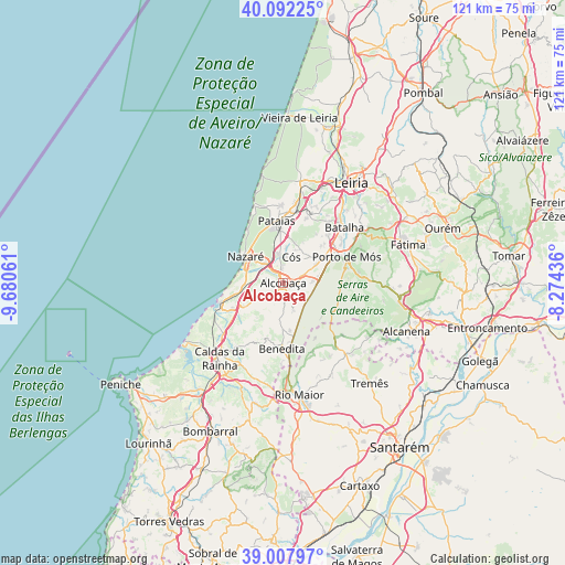
Alcobaça GPS coordinates[2]
39° 33' 8.028" North, 8° 58' 38.964" West
| Map corner | latitude | longitude |
|---|---|---|
| Upper-left | 40.09225°, | -9.68061° |
| Center: | 39.55223°, | -8.97749° |
| Lower-right: | 39.00797°, | -8.27436° |
| Map W x H: | 120.6×120.6 km | = 74.9×74.9mi |
| max Lat: | 42.11337° ⇑51.4% North |
| Alcobaça: | 39.55223° |
| min Lat: | ⇓48.6% South 32.6448° |
| min Long | Alcobaça | max Long |
| -31.17847° | -8.97749° | -6.27308° |
| W 26.8%⇐ | ⇒73.2% E |
Elevation
Elevation of Alcobaça is 38 m = 125 ft, and this is 139 m = 456 ft below average elevation for this country.
| Max E: |
1008 m = 3307 ft | 76.4% |
| Avg. | 177 m = 581 ft | |
| Alcobaça | 38 m = 125 ft | |
Min E: |
-128 m = -420 ft | 23.6% |
See also: Portugal elevation on elevation.city.
Geographical zone
Alcobaça is located in North temperate zone (between Tropic of Cancer and the Arctic Circle). Distance of this Northern Tropic circle is 1791.9 km =1113.4 mi to South.| Distance of | km | miles | from Alcobaça |
|---|---|---|---|
| North Pole | 5609.3 | 3485.5 | to North |
| Arctic Circle | 3003.4 | 1866.2 | to North |
| Tropic Cancer | 1791.9 | 1113.4 | to South |
| Equator | 4397.8 | 2732.7 | to South |


Nearby cities:
15 places around Alcobaça: (largest is in red/bold)
• Alfeizerão
12.3 km =7.6 mi,  241°
241°
• Aljubarrota
4.5 km =2.8 mi,  68°
68°
• Benedita
14.2 km =8.8 mi,  177°
177°
• Cela
5.1 km =3.2 mi,  255°
255°
• Famalicão
9.2 km =5.7 mi, 259°
• Maceira
16.7 km =10.4 mi,  25°
25°
• Nazaré
9.6 km =6 mi,  305°
305°
• Pataias
13.2 km =8.2 mi,  353°
353°
• Porto de Mós
14.7 km =9.1 mi, 67°
• Salir de Matos
16.7 km =10.4 mi,  216°
216°
• Salir do Porto
16.6 km =10.3 mi,  247°
247°
• São Martinho do Porto
13.8 km =8.6 mi, 252°
• Turquel
9.8 km =6.1 mi, 179°
• Valado de Frades
5.3 km =3.3 mi, 312°
• Vestiaria
1.8 km =1.1 mi,  271°
271°
Sources, notices
• [Note1] Compared only with cities in Portugal existing in our database
• [Src1] Map data: © OpenStreetMap contributors (CC-BY-SA)
• [Src2] Other city data from geonames.org with taken over terms of usage.
• [Src3] Geographical zone / Annual Mean Temperature by Robert A. Rohde @ Wikipedia
