São Jorge geodata
São Jorge (Madeira) is a populated place; located in Portugal in Atlantic/Madeira (GMT+0) time zone. With population of 1,473 people, there are 692 cities with bigger population in this country. Compared to other cities in Portugal, 96.6% of cities are located further ↑North; 90.7% of cities are located further →East and 61.8% of cities have higher elevation than São Jorge. Note1


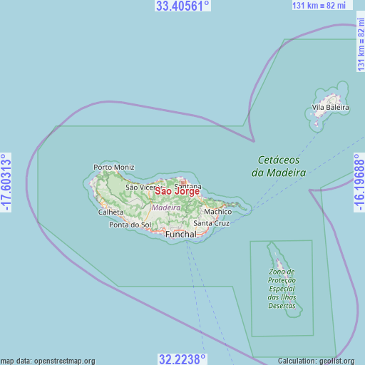
São Jorge GPS coordinates[2]
32° 49' 0.012" North, 16° 54' 0" West
| Map corner | latitude | longitude |
|---|---|---|
| Upper-left | 33.40561°, | -17.60313° |
| Center: | 32.81667°, | -16.9° |
| Lower-right: | 32.2238°, | -16.19688° |
| Map W x H: | 131.4×131.4 km | = 81.6×81.6mi |
| max Lat: | 42.11337° ⇑96.6% North |
| São Jorge: | 32.81667° |
| min Lat: | ⇓3.4% South 32.6448° |
| min Long | São Jorge | max Long |
| -31.17847° | -16.9° | -6.27308° |
| W 9.3%⇐ | ⇒90.7% E |
Elevation
Elevation of São Jorge is 73 m = 240 ft, and this is 104 m = 341 ft below average elevation for this country.
| Max E: |
1008 m = 3307 ft | 61.8% |
| Avg. | 177 m = 581 ft | |
| São Jorge | 73 m = 240 ft | |
Min E: |
-128 m = -420 ft | 38.2% |
See also: Portugal elevation on elevation.city.
Geographical zone
São Jorge is located in North temperate zone (between Tropic of Cancer and the Arctic Circle). Distance of this Northern Tropic circle is 1043 km =648.1 mi to South.| Distance of | km | miles | from São Jorge |
|---|---|---|---|
| North Pole | 6358.2 | 3950.8 | to North |
| Arctic Circle | 3752.3 | 2331.6 | to North |
| Tropic Cancer | 1043 | 648.1 | to South |
| Equator | 3648.9 | 2267.3 | to South |


Nearby cities:
15 places around São Jorge: (largest is in red/bold)
• Boaventura
6.8 km =4.2 mi,  271°
271°
• Camacha
16.1 km =10 mi,  161°
161°
• Caniçal
17.4 km =10.8 mi,  119°
119°
• Curral das Freiras
12.6 km =7.8 mi,  211°
211°
• Faial
6 km =3.7 mi,  128°
128°
• Funchal
17 km =10.6 mi,  188°
188°
• Machico
16.7 km =10.4 mi, 132°
• Nossa Senhora do Monte
16.7 km =10.4 mi,  180°
180°
• Porto da Cruz
8.4 km =5.2 mi, 131°
• Santa Cruz
17.4 km =10.8 mi,  145°
145°
• Santana
2.4 km =1.5 mi,  139°
139°
• Santo da Serra
12.9 km =8 mi, 144°
• São Roque
16.8 km =10.4 mi, 185°
• São Vicente
13.6 km =8.5 mi,  260°
260°
• Água de Pena
17.1 km =10.6 mi, 138°
Sources, notices
• [Note1] Compared only with cities in Portugal existing in our database
• [Src1] Map data: © OpenStreetMap contributors (CC-BY-SA)
• [Src2] Other city data from geonames.org with taken over terms of usage.
• [Src3] Geographical zone / Annual Mean Temperature by Robert A. Rohde @ Wikipedia
