Alvalade geodata
Alvalade (Lisbon) is a populated place; located in Portugal in Europe/Lisbon (GMT+1) time zone. With population of 31,813 people, there are 47 cities with bigger population in this country. Compared to other cities in Portugal, 71.5% of cities are located further ↑North; 80.2% of cities are located further →East and 55.5% of cities have higher elevation than Alvalade. Note1


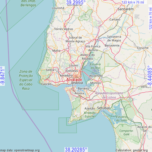
Alvalade GPS coordinates[2]
38° 45' 11.808" North, 9° 8' 38.292" West
| Map corner | latitude | longitude |
|---|---|---|
| Upper-left | 39.2995°, | -9.8471° |
| Center: | 38.75328°, | -9.14397° |
| Lower-right: | 38.20285°, | -8.44085° |
| Map W x H: | 121.9×121.9 km | = 75.7×75.7mi |
| max Lat: | 42.11337° ⇑71.5% North |
| Alvalade: | 38.75328° |
| min Lat: | ⇓28.5% South 32.6448° |
| min Long | Alvalade | max Long |
| -31.17847° | -9.14397° | -6.27308° |
| W 19.8%⇐ | ⇒80.2% E |
Elevation
Elevation of Alvalade is 91 m = 299 ft, and this is 86 m = 282 ft below average elevation for this country.
| Max E: |
1008 m = 3307 ft | 55.5% |
| Avg. | 177 m = 581 ft | |
| Alvalade | 91 m = 299 ft | |
Min E: |
-128 m = -420 ft | 44.5% |
See also: Portugal elevation on elevation.city.
Geographical zone
Alvalade is located in North temperate zone (between Tropic of Cancer and the Arctic Circle). Distance of this Northern Tropic circle is 1703 km =1058.2 mi to South.| Distance of | km | miles | from Alvalade |
|---|---|---|---|
| North Pole | 5698.1 | 3540.6 | to North |
| Arctic Circle | 3092.2 | 1921.4 | to North |
| Tropic Cancer | 1703 | 1058.2 | to South |
| Equator | 4309 | 2677.5 | to South |


Nearby cities:
15 places around Alvalade: (largest is in red/bold)
• Apelação
6.8 km =4.2 mi,  8°
8°
• Beato António
4.2 km =2.6 mi,  122°
122°
• Benfica
5.1 km =3.2 mi,  266°
266°
• Camarate
5.8 km =3.6 mi, 13°
• Charneca
3.4 km =2.1 mi,  0°
0°
• Lisbon
4.2 km =2.6 mi,  167°
167°
• Moscavide e Portela
4.6 km =2.9 mi,  51°
51°
• Odivelas
5.6 km =3.5 mi,  321°
321°
• Olivais
3.7 km =2.3 mi,  60°
60°
• Olival do Basto
4.6 km =2.9 mi,  335°
335°
• Pontinha
5.1 km =3.2 mi,  288°
288°
• Prior Velho
4.7 km =2.9 mi,  24°
24°
• Póvoa de Santo Adrião
5.6 km =3.5 mi, 339°
• Sacavém
5.3 km =3.3 mi,  35°
35°
• Santos-o-Velho
5.3 km =3.3 mi,  191°
191°
Sources, notices
• [Note1] Compared only with cities in Portugal existing in our database
• [Src1] Map data: © OpenStreetMap contributors (CC-BY-SA)
• [Src2] Other city data from geonames.org with taken over terms of usage.
• [Src3] Geographical zone / Annual Mean Temperature by Robert A. Rohde @ Wikipedia
