Vila Velha de Ródão geodata
Vila Velha de Ródão (Castelo Branco) is a populated place; located in Portugal in Europe/Lisbon (GMT+1) time zone. With population of 3,521 people, there are 557 cities with bigger population in this country. Compared to other cities in Portugal, 50.2% of cities are located further ↓South; 88.3% of cities are located further ←West and 66.1% of cities have lower elevation than Vila Velha de Ródão. Note1
Administrative division(s):
- Level 1: Castelo Branco
- Level 2: Vila Velha de Ródão
- Level 3: Vila Velha de Ródão


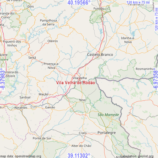
Vila Velha de Ródão GPS coordinates[2]
39° 39' 23.256" North, 7° 40' 36.12" West
| Map corner | latitude | longitude |
|---|---|---|
| Upper-left | 40.19566°, | -8.37983° |
| Center: | 39.65646°, | -7.6767° |
| Lower-right: | 39.11302°, | -6.97358° |
| Map W x H: | 120.4×120.4 km | = 74.8×74.8mi |
| max Lat: | 42.11337° ⇑49.8% North |
| Vila Velha de Ródão: | 39.65646° |
| min Lat: | ⇓50.2% South 32.6448° |
| min Long | Vila Velha de R | max Long |
| -31.17847° | -7.6767° | -6.27308° |
| W 88.3%⇐ | ⇒11.7% E |
Elevation
Elevation of Vila Velha de Ródão is 183 m = 600 ft, and this is 6 m = 20 ft above average elevation for this country.
| Max E: |
1008 m = 3307 ft | 33.9% |
| Vila Velha de Ródão | 183 m 600 ft | |
| Avg. | 177 m = 581 ft | |
Min E: |
-128 m = -420 ft | 66.1% |
See also: Portugal elevation on elevation.city.
Geographical zone
Vila Velha de Ródão is located in North temperate zone (between Tropic of Cancer and the Arctic Circle). Distance of this Northern Tropic circle is 1803.5 km =1120.6 mi to South.| Distance of | km | miles | from Vila Velha de Ródão |
|---|---|---|---|
| North Pole | 5597.7 | 3478.2 | to North |
| Arctic Circle | 2991.8 | 1859 | to North |
| Tropic Cancer | 1803.5 | 1120.6 | to South |
| Equator | 4409.4 | 2739.9 | to South |


Nearby cities:
15 places around Vila Velha de Ródão: (largest is in red/bold)
• Alagoa
34.9 km =21.7 mi,  160°
160°
• Alcains
34.5 km =21.4 mi,  33°
33°
• Atalaia
28 km =17.4 mi,  216°
216°
• Carvoeiro
21.4 km =13.3 mi,  260°
260°
• Castelo Branco
24.3 km =15.1 mi,  40°
40°
• Castelo de Vide
32.7 km =20.3 mi,  144°
144°
• Comenda
29.9 km =18.6 mi,  197°
197°
• Gavião
30.7 km =19.1 mi,  225°
225°
• Gáfete
27.3 km =17 mi,  181°
181°
• Marvão
38.9 km =24.2 mi, 138°
• Mação
29.4 km =18.3 mi,  247°
247°
• Nisa
15.9 km =9.9 mi,  171°
171°
• Oleiros
35.5 km =22.1 mi,  325°
325°
• Proença-a-Nova
23.7 km =14.7 mi,  296°
296°
• Póvoa e Meadas
21.2 km =13.2 mi, 139°
Sources, notices
• [Note1] Compared only with cities in Portugal existing in our database
• [Src1] Map data: © OpenStreetMap contributors (CC-BY-SA)
• [Src2] Other city data from geonames.org with taken over terms of usage.
• [Src3] Geographical zone / Annual Mean Temperature by Robert A. Rohde @ Wikipedia
