Alcanhões geodata
Alcanhões (Santarém) is a populated place; located in Portugal in Europe/Lisbon (GMT+1) time zone. With population of 1,469 people, there are 694 cities with bigger population in this country. Compared to other cities in Portugal, 58.6% of cities are located further ↑North; 59.5% of cities are located further →East and 64.7% of cities have higher elevation than Alcanhões. Note1


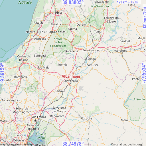
Alcanhões GPS coordinates[2]
39° 17' 45.708" North, 8° 39' 30.492" West
| Map corner | latitude | longitude |
|---|---|---|
| Upper-left | 39.83805°, | -9.36159° |
| Center: | 39.29603°, | -8.65847° |
| Lower-right: | 38.74978°, | -7.95534° |
| Map W x H: | 121×121 km | = 75.2×75.2mi |
| max Lat: | 42.11337° ⇑58.6% North |
| Alcanhões: | 39.29603° |
| min Lat: | ⇓41.4% South 32.6448° |
| min Long | Alcanhões | max Long |
| -31.17847° | -8.65847° | -6.27308° |
| W 40.5%⇐ | ⇒59.5% E |
Elevation
Elevation of Alcanhões is 63 m = 207 ft, and this is 114 m = 374 ft below average elevation for this country.
| Max E: |
1008 m = 3307 ft | 64.7% |
| Avg. | 177 m = 581 ft | |
| Alcanhões | 63 m = 207 ft | |
Min E: |
-128 m = -420 ft | 35.3% |
See also: Portugal elevation on elevation.city.
Geographical zone
Alcanhões is located in North temperate zone (between Tropic of Cancer and the Arctic Circle). Distance of this Northern Tropic circle is 1763.4 km =1095.7 mi to South.| Distance of | km | miles | from Alcanhões |
|---|---|---|---|
| North Pole | 5637.8 | 3503.2 | to North |
| Arctic Circle | 3031.9 | 1883.9 | to North |
| Tropic Cancer | 1763.4 | 1095.7 | to South |
| Equator | 4369.3 | 2715 | to South |


Nearby cities:
15 places around Alcanhões: (largest is in red/bold)
• Alcanena
18.1 km =11.2 mi,  357°
357°
• Almeirim
10.1 km =6.3 mi,  164°
164°
• Alpiarça
7.9 km =4.9 mi,  123°
123°
• Amiães de Baixo
17.6 km =10.9 mi,  338°
338°
• Azinhaga
12.5 km =7.8 mi,  62°
62°
• Bemfica
17.2 km =10.7 mi,  188°
188°
• Cartaxo
18.7 km =11.6 mi,  216°
216°
• Fazendas de Almeirim
15.4 km =9.6 mi,  150°
150°
• Golegã
19.1 km =11.9 mi,  50°
50°
• Monsanto
19 km =11.8 mi,  346°
346°
• Santarém
7.3 km =4.5 mi,  197°
197°
• São Vicente do Paul
6.7 km =4.2 mi,  27°
27°
• Vale de Figueira
2.8 km =1.7 mi,  67°
67°
• Vale de Santarém
13.1 km =8.1 mi,  206°
206°
• Vila Chã de Ourique
16.6 km =10.3 mi, 214°
Sources, notices
• [Note1] Compared only with cities in Portugal existing in our database
• [Src1] Map data: © OpenStreetMap contributors (CC-BY-SA)
• [Src2] Other city data from geonames.org with taken over terms of usage.
• [Src3] Geographical zone / Annual Mean Temperature by Robert A. Rohde @ Wikipedia
