Alpiarça geodata
Alpiarça (Santarém) is a seat of a second-order administrative division; located in Portugal in Europe/Lisbon (GMT+1) time zone. With population of 7,946 people, there are 282 cities with bigger population in this country. Compared to other cities in Portugal, 59% of cities are located further ↑North; 51.7% of cities are located further →East and 84.7% of cities have higher elevation than Alpiarça. Note1


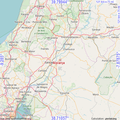
Alpiarça GPS coordinates[2]
39° 15' 25.632" North, 8° 34' 54.732" West
| Map corner | latitude | longitude |
|---|---|---|
| Upper-left | 39.79944°, | -9.285° |
| Center: | 39.25712°, | -8.58187° |
| Lower-right: | 38.71057°, | -7.87875° |
| Map W x H: | 121.1×121.1 km | = 75.2×75.2mi |
| max Lat: | 42.11337° ⇑59% North |
| Alpiarça: | 39.25712° |
| min Lat: | ⇓41% South 32.6448° |
| min Long | Alpiarça | max Long |
| -31.17847° | -8.58187° | -6.27308° |
| W 48.3%⇐ | ⇒51.7% E |
Elevation
Elevation of Alpiarça is 24 m = 79 ft, and this is 153 m = 502 ft below average elevation for this country.
| Max E: |
1008 m = 3307 ft | 84.7% |
| Avg. | 177 m = 581 ft | |
| Alpiarça | 24 m = 79 ft | |
Min E: |
-128 m = -420 ft | 15.3% |
See also: Portugal elevation on elevation.city.
Geographical zone
Alpiarça is located in North temperate zone (between Tropic of Cancer and the Arctic Circle). Distance of this Northern Tropic circle is 1759.1 km =1093.1 mi to South.| Distance of | km | miles | from Alpiarça |
|---|---|---|---|
| North Pole | 5642.1 | 3505.8 | to North |
| Arctic Circle | 3036.2 | 1886.6 | to North |
| Tropic Cancer | 1759.1 | 1093.1 | to South |
| Equator | 4365 | 2712.3 | to South |


Nearby cities:
15 places around Alpiarça: (largest is in red/bold)
• Alcanena
23.7 km =14.7 mi,  341°
341°
• Alcanhões
7.9 km =4.9 mi,  303°
303°
• Almeirim
6.6 km =4.1 mi,  215°
215°
• Azinhaga
11.1 km =6.9 mi,  23°
23°
• Bemfica
15.6 km =9.7 mi, 215°
• Cartaxo
20.7 km =12.9 mi,  238°
238°
• Fazendas de Almeirim
9.1 km =5.7 mi,  173°
173°
• Golegã
18.4 km =11.4 mi,  26°
26°
• Pinheiro Grande
19.7 km =12.2 mi,  40°
40°
• Riachos
21.7 km =13.5 mi, 15°
• Santarém
9.1 km =5.7 mi,  253°
253°
• São Vicente do Paul
10.8 km =6.7 mi, 341°
• Vale de Figueira
6.7 km =4.2 mi,  323°
323°
• Vale de Santarém
14.6 km =9.1 mi, 239°
• Vila Chã de Ourique
18.5 km =11.5 mi, 239°
Sources, notices
• [Note1] Compared only with cities in Portugal existing in our database
• [Src1] Map data: © OpenStreetMap contributors (CC-BY-SA)
• [Src2] Other city data from geonames.org with taken over terms of usage.
• [Src3] Geographical zone / Annual Mean Temperature by Robert A. Rohde @ Wikipedia
