Viana do Castelo geodata
Viana do Castelo is a seat of a first-order administrative division; located in Portugal in Europe/Lisbon (GMT+1) time zone. With population of 36,148 people, there are 35 cities with bigger population in this country. Compared to other cities in Portugal, 97.3% of cities are located further ↓South; 69.6% of cities are located further →East and 93.2% of cities have higher elevation than Viana do Castelo. Note1
Administrative division(s):
- Level 1: Viana do Castelo
- Level 2: Viana do Castelo
- Level 3: Viana do Castelo (Monserrate)


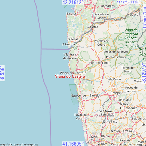
Viana do Castelo GPS coordinates[2]
41° 41' 35.628" North, 8° 49' 58.332" West
| Map corner | latitude | longitude |
|---|---|---|
| Upper-left | 42.21612°, | -9.536° |
| Center: | 41.69323°, | -8.83287° |
| Lower-right: | 41.16605°, | -8.12975° |
| Map W x H: | 116.8×116.8 km | = 72.6×72.6mi |
| max Lat: | 42.11337° ⇑2.7% North |
| Viana do Castelo: | 41.69323° |
| min Lat: | ⇓97.3% South 32.6448° |
| min Long | Viana do Castel | max Long |
| -31.17847° | -8.83287° | -6.27308° |
| W 30.4%⇐ | ⇒69.6% E |
Elevation
Elevation of Viana do Castelo is 12 m = 39 ft, and this is 165 m = 541 ft below average elevation for this country.
| Max E: |
1008 m = 3307 ft | 93.2% |
| Avg. | 177 m = 581 ft | |
| Viana do Castelo | 12 m = 39 ft | |
Min E: |
-128 m = -420 ft | 6.8% |
See also: Portugal elevation on elevation.city.
Geographical zone
Viana do Castelo is located in North temperate zone (between Tropic of Cancer and the Arctic Circle). Distance of this Northern Tropic circle is 2029.9 km =1261.3 mi to South.| Distance of | km | miles | from Viana do Castelo |
|---|---|---|---|
| North Pole | 5371.2 | 3337.5 | to North |
| Arctic Circle | 2765.3 | 1718.3 | to North |
| Tropic Cancer | 2029.9 | 1261.3 | to South |
| Equator | 4635.9 | 2880.6 | to South |


Nearby cities:
15 places around Viana do Castelo: (largest is in red/bold)
• Apúlia
23.8 km =14.8 mi,  166°
166°
• Apúlia e Fão
20.8 km =12.9 mi, 166°
• Areosa
3.4 km =2.1 mi,  323°
323°
• Darque
5.6 km =3.5 mi,  101°
101°
• Esposende
18 km =11.2 mi, 166°
• Fornelos
23.4 km =14.5 mi,  146°
146°
• Gandra
19.9 km =12.4 mi,  162°
162°
• Marinhas
15.5 km =9.6 mi, 164°
• Mariz
22.8 km =14.2 mi,  143°
143°
• Meadela
3.4 km =2.1 mi,  64°
64°
• Perelhal
21.6 km =13.4 mi, 146°
• Ponte de Lima
22.2 km =13.8 mi,  68°
68°
• Vila Cova
18.5 km =11.5 mi, 148°
• Vila Frescainha
23.5 km =14.6 mi, 136°
• Vila Praia de Âncora
13.2 km =8.2 mi,  352°
352°
Sources, notices
• [Note1] Compared only with cities in Portugal existing in our database
• [Src1] Map data: © OpenStreetMap contributors (CC-BY-SA)
• [Src2] Other city data from geonames.org with taken over terms of usage.
• [Src3] Geographical zone / Annual Mean Temperature by Robert A. Rohde @ Wikipedia
