Ponte de Lima geodata
Ponte de Lima (Viana do Castelo) is a seat of a second-order administrative division; located in Portugal in Europe/Lisbon (GMT+1) time zone. With population of 44,667 people, there are 25 cities with bigger population in this country. Compared to other cities in Portugal, 98.2% of cities are located further ↓South; 51.9% of cities are located further →East and 92.5% of cities have higher elevation than Ponte de Lima. Note1


Ponte de Lima GPS coordinates[2]
41° 46' 1.884" North, 8° 35' 2.148" West
| Map corner | latitude | longitude |
|---|---|---|
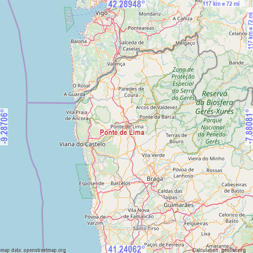
| Upper-left | 42.28948°, | -9.28706° |
| Center: | 41.76719°, | -8.58393° |
| Lower-right: | 41.24062°, | -7.88081° |
| Map W x H: | 116.6×116.6 km | = 72.5×72.5mi |
| max Lat: | 42.11337° ⇑1.8% North |
| Ponte de Lima: | 41.76719° |
| min Lat: | ⇓98.2% South 32.6448° |
| min Long | Ponte de Lima | max Long |
| -31.17847° | -8.58393° | -6.27308° |
| W 48.1%⇐ | ⇒51.9% E |
Elevation
Elevation of Ponte de Lima is 13 m = 43 ft, and this is 164 m = 538 ft below average elevation for this country.
| Max E: |
1008 m = 3307 ft | 92.5% |
| Avg. | 177 m = 581 ft | |
| Ponte de Lima | 13 m = 43 ft | |
Min E: |
-128 m = -420 ft | 7.5% |
See also: Ponte de Lima elevation on elevation.city.
Geographical zone
Ponte de Lima is located in North temperate zone (between Tropic of Cancer and the Arctic Circle). Distance of this Northern Tropic circle is 2038.2 km =1266.5 mi to South.| Distance of | km | miles | from Ponte de Lima |
|---|---|---|---|
| North Pole | 5363 | 3332.4 | to North |
| Arctic Circle | 2757.1 | 1713.2 | to North |
| Tropic Cancer | 2038.2 | 1266.5 | to South |
| Equator | 4644.1 | 2885.7 | to South |


Nearby cities:
15 places around Ponte de Lima: (largest is in red/bold)
• Aboim da Nóbrega
16 km =9.9 mi,  97°
97°
• Arcos de Valdevez
16.3 km =10.1 mi,  57°
57°
• Caldelas
19.9 km =12.4 mi,  122°
122°
• Darque
17.8 km =11.1 mi,  238°
238°
• Lago
21.6 km =13.4 mi,  138°
138°
• Meadela
18.9 km =11.7 mi,  249°
249°
• Mozelos
19.1 km =11.9 mi,  54°
54°
• Paredes de Coura
16 km =9.9 mi,  6°
6°
• Ponte da Barca
14.6 km =9.1 mi,  73°
73°
• Prado
20.9 km =13 mi,  151°
151°
• Rendufe
21.2 km =13.2 mi, 136°
• Rubiãis
14.7 km =9.1 mi,  346°
346°
• Sande
17.5 km =10.9 mi,  114°
114°
• Viana do Castelo
22.2 km =13.8 mi, 248°
• Vila Verde
18.1 km =11.2 mi, 137°
Sources, notices
• [Note1] Compared only with cities in Portugal existing in our database
• [Src1] Map data: © OpenStreetMap contributors (CC-BY-SA)
• [Src2] Other city data from geonames.org with taken over terms of usage.
• [Src3] Geographical zone / Annual Mean Temperature by Robert A. Rohde @ Wikipedia
