Fânzeres geodata
Fânzeres (Porto) is a populated place; located in Portugal in Europe/Lisbon (GMT+1) time zone. With population of 23,916 people, there are 73 cities with bigger population in this country. Compared to other cities in Portugal, 76.8% of cities are located further ↓South; 52.6% of cities are located further ←West and 62.1% of cities have lower elevation than Fânzeres. Note1


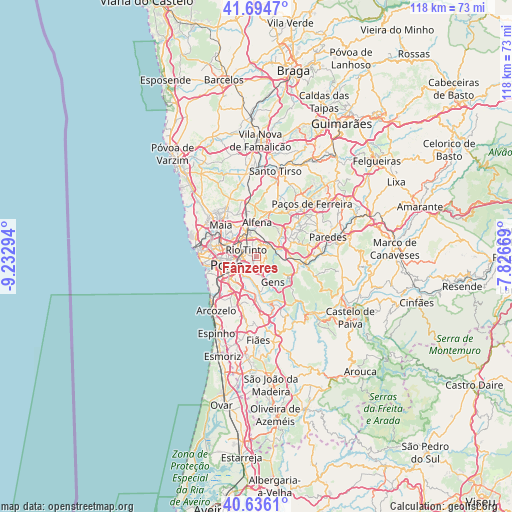
Fânzeres GPS coordinates[2]
41° 10' 3.144" North, 8° 31' 47.316" West
| Map corner | latitude | longitude |
|---|---|---|
| Upper-left | 41.6947°, | -9.23294° |
| Center: | 41.16754°, | -8.52981° |
| Lower-right: | 40.6361°, | -7.82669° |
| Map W x H: | 117.7×117.7 km | = 73.1×73.1mi |
| max Lat: | 42.11337° ⇑23.2% North |
| Fânzeres: | 41.16754° |
| min Lat: | ⇓76.8% South 32.6448° |
| min Long | Fânzeres | max Long |
| -31.17847° | -8.52981° | -6.27308° |
| W 52.6%⇐ | ⇒47.4% E |
Elevation
Elevation of Fânzeres is 166 m = 545 ft, and this is 11 m = 36 ft below average elevation for this country.
| Max E: |
1008 m = 3307 ft | 37.9% |
| Avg. | 177 m = 581 ft | |
| Fânzeres | 166 m = 545 ft | |
Min E: |
-128 m = -420 ft | 62.1% |
See also: Portugal elevation on elevation.city.
Geographical zone
Fânzeres is located in North temperate zone (between Tropic of Cancer and the Arctic Circle). Distance of this Northern Tropic circle is 1971.5 km =1225 mi to South.| Distance of | km | miles | from Fânzeres |
|---|---|---|---|
| North Pole | 5429.7 | 3373.9 | to North |
| Arctic Circle | 2823.8 | 1754.6 | to North |
| Tropic Cancer | 1971.5 | 1225 | to South |
| Equator | 4577.4 | 2844.3 | to South |


Nearby cities:
15 places around Fânzeres: (largest is in red/bold)
• Avintes
7 km =4.3 mi,  195°
195°
• Baguim do Monte
2.9 km =1.8 mi,  340°
340°
• Campo
5.8 km =3.6 mi,  70°
70°
• Ermesinde
5.8 km =3.6 mi, 340°
• Gondomar
2.6 km =1.6 mi,  184°
184°
• Jovim
6.3 km =3.9 mi,  171°
171°
• Milheirós
7.2 km =4.5 mi,  316°
316°
• Oliveira do Douro
6.6 km =4.1 mi,  223°
223°
• Pedrouços
5.3 km =3.3 mi,  296°
296°
• Porto
7.1 km =4.4 mi,  253°
253°
• Rio Tinto
2.8 km =1.7 mi, 296°
• São Pedro da Cova
3.7 km =2.3 mi,  137°
137°
• Valbom
5 km =3.1 mi,  212°
212°
• Valongo
3.5 km =2.2 mi,  47°
47°
• Águas Santas
6.1 km =3.8 mi, 320°
Sources, notices
• [Note1] Compared only with cities in Portugal existing in our database
• [Src1] Map data: © OpenStreetMap contributors (CC-BY-SA)
• [Src2] Other city data from geonames.org with taken over terms of usage.
• [Src3] Geographical zone / Annual Mean Temperature by Robert A. Rohde @ Wikipedia
