Olival geodata
Olival (Porto) is a populated place; located in Portugal in Europe/Lisbon (GMT+1) time zone. With population of 5,715 people, there are 381 cities with bigger population in this country. Compared to other cities in Portugal, 71.7% of cities are located further ↓South; 51.5% of cities are located further ←West and 66.4% of cities have lower elevation than Olival. Note1


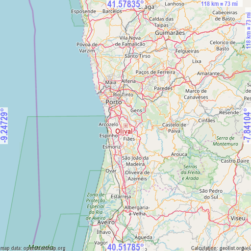
Olival GPS coordinates[2]
41° 3' 0.864" North, 8° 32' 38.976" West
| Map corner | latitude | longitude |
|---|---|---|
| Upper-left | 41.57835°, | -9.24729° |
| Center: | 41.05024°, | -8.54416° |
| Lower-right: | 40.51785°, | -7.84104° |
| Map W x H: | 117.9×117.9 km | = 73.3×73.3mi |
| max Lat: | 42.11337° ⇑28.3% North |
| Olival: | 41.05024° |
| min Lat: | ⇓71.7% South 32.6448° |
| min Long | Olival | max Long |
| -31.17847° | -8.54416° | -6.27308° |
| W 51.5%⇐ | ⇒48.5% E |
Elevation
Elevation of Olival is 184 m = 604 ft, and this is 7 m = 23 ft above average elevation for this country.
| Max E: |
1008 m = 3307 ft | 33.6% |
| Olival | 184 m 604 ft | |
| Avg. | 177 m = 581 ft | |
Min E: |
-128 m = -420 ft | 66.4% |
See also: Portugal elevation on elevation.city.
Geographical zone
Olival is located in North temperate zone (between Tropic of Cancer and the Arctic Circle). Distance of this Northern Tropic circle is 1958.4 km =1216.9 mi to South.| Distance of | km | miles | from Olival |
|---|---|---|---|
| North Pole | 5442.7 | 3381.9 | to North |
| Arctic Circle | 2836.8 | 1762.7 | to North |
| Tropic Cancer | 1958.4 | 1216.9 | to South |
| Equator | 4564.4 | 2836.2 | to South |


Nearby cities:
15 places around Olival: (largest is in red/bold)
• Argoncilhe
2.8 km =1.7 mi,  170°
170°
• Avintes
6.4 km =4 mi,  354°
354°
• Canelas
6 km =3.7 mi,  308°
308°
• Fiães
6.4 km =4 mi, 165°
• Foz do Sousa
6.3 km =3.9 mi,  34°
34°
• Grijó
3.9 km =2.4 mi,  231°
231°
• Jovim
7.1 km =4.4 mi,  17°
17°
• Lourosa
7.4 km =4.6 mi,  184°
184°
• Nogueira da Regedoura
6.4 km =4 mi,  218°
218°
• Perozinho
3.8 km =2.4 mi,  295°
295°
• Sandim
3.5 km =2.2 mi,  118°
118°
• Sermonde
3.4 km =2.1 mi,  264°
264°
• Serzedo
6 km =3.7 mi,  270°
270°
• São Félix da Marinha
6.8 km =4.2 mi, 256°
• Vilar de Andorinho
7.1 km =4.4 mi,  330°
330°
Sources, notices
• [Note1] Compared only with cities in Portugal existing in our database
• [Src1] Map data: © OpenStreetMap contributors (CC-BY-SA)
• [Src2] Other city data from geonames.org with taken over terms of usage.
• [Src3] Geographical zone / Annual Mean Temperature by Robert A. Rohde @ Wikipedia
