Rubiãis geodata
Rubiãis (Viana do Castelo) is a populated place; located in Portugal in Europe/Lisbon (GMT+1) time zone. With population of 548 people, there are 821 cities with bigger population in this country. Compared to other cities in Portugal, 99.2% of cities are located further ↓South; 55.8% of cities are located further →East and 73.5% of cities have lower elevation than Rubiãis. Note1


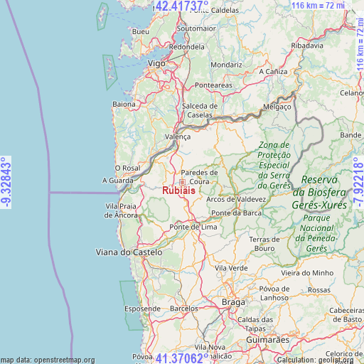
Rubiãis GPS coordinates[2]
41° 53' 46.104" North, 8° 37' 31.08" West
| Map corner | latitude | longitude |
|---|---|---|
| Upper-left | 42.41737°, | -9.32843° |
| Center: | 41.89614°, | -8.6253° |
| Lower-right: | 41.37062°, | -7.92218° |
| Map W x H: | 116.4×116.4 km | = 72.3×72.3mi |
| max Lat: | 42.11337° ⇑0.8% North |
| Rubiãis: | 41.89614° |
| min Lat: | ⇓99.2% South 32.6448° |
| min Long | Rubiãis | max Long |
| -31.17847° | -8.6253° | -6.27308° |
| W 44.2%⇐ | ⇒55.8% E |
Elevation
Elevation of Rubiãis is 222 m = 728 ft, and this is 45 m = 148 ft above average elevation for this country.
| Max E: |
1008 m = 3307 ft | 26.5% |
| Rubiãis | 222 m 728 ft | |
| Avg. | 177 m = 581 ft | |
Min E: |
-128 m = -420 ft | 73.5% |
See also: Portugal elevation on elevation.city.
Geographical zone
Rubiãis is located in North temperate zone (between Tropic of Cancer and the Arctic Circle). Distance of this Northern Tropic circle is 2052.5 km =1275.4 mi to South.| Distance of | km | miles | from Rubiãis |
|---|---|---|---|
| North Pole | 5348.6 | 3323.5 | to North |
| Arctic Circle | 2742.8 | 1704.3 | to North |
| Tropic Cancer | 2052.5 | 1275.4 | to South |
| Equator | 4658.4 | 2894.6 | to South |


Nearby cities:
15 places around Rubiãis: (largest is in red/bold)
• Aboim da Nóbrega
25.3 km =15.7 mi,  130°
130°
• Arcos de Valdevez
17.9 km =11.1 mi,  107°
107°
• Areosa
27.6 km =17.1 mi,  224°
224°
• Darque
26.4 km =16.4 mi,  206°
206°
• Meadela
25.4 km =15.8 mi, 213°
• Monção
23.6 km =14.7 mi,  30°
30°
• Mozelos
19.1 km =11.9 mi,  99°
99°
• Paredes de Coura
5.5 km =3.4 mi,  73°
73°
• Ponte da Barca
20.1 km =12.5 mi,  120°
120°
• Ponte de Lima
14.7 km =9.1 mi,  166°
166°
• Valenza
14.3 km =8.9 mi,  356°
356°
• Valença
15.1 km =9.4 mi,  353°
353°
• Viana do Castelo
28.4 km =17.6 mi, 217°
• Vila Nova de Cerveira
10.9 km =6.8 mi,  297°
297°
• Vila Praia de Âncora
21.1 km =13.1 mi,  243°
243°
Sources, notices
• [Note1] Compared only with cities in Portugal existing in our database
• [Src1] Map data: © OpenStreetMap contributors (CC-BY-SA)
• [Src2] Other city data from geonames.org with taken over terms of usage.
• [Src3] Geographical zone / Annual Mean Temperature by Robert A. Rohde @ Wikipedia
