Mozelos geodata
Mozelos (Viana do Castelo) is a populated place; located in Portugal in Europe/Lisbon (GMT+1) time zone. With population of 7,230 people, there are 311 cities with bigger population in this country. Compared to other cities in Portugal, 99.1% of cities are located further ↓South; 63.2% of cities are located further ←West and 51.5% of cities have higher elevation than Mozelos. Note1


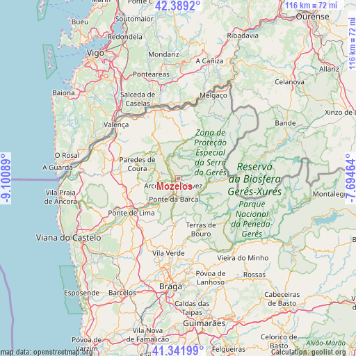
Mozelos GPS coordinates[2]
41° 52' 3.864" North, 8° 23' 51.936" West
| Map corner | latitude | longitude |
|---|---|---|
| Upper-left | 42.3892°, | -9.10089° |
| Center: | 41.86774°, | -8.39776° |
| Lower-right: | 41.34199°, | -7.69464° |
| Map W x H: | 116.4×116.4 km | = 72.3×72.3mi |
| max Lat: | 42.11337° ⇑0.9% North |
| Mozelos: | 41.86774° |
| min Lat: | ⇓99.1% South 32.6448° |
| min Long | Mozelos | max Long |
| -31.17847° | -8.39776° | -6.27308° |
| W 63.2%⇐ | ⇒36.8% E |
Elevation
Elevation of Mozelos is 108 m = 354 ft, and this is 69 m = 226 ft below average elevation for this country.
| Max E: |
1008 m = 3307 ft | 51.5% |
| Avg. | 177 m = 581 ft | |
| Mozelos | 108 m = 354 ft | |
Min E: |
-128 m = -420 ft | 48.5% |
See also: Portugal elevation on elevation.city.
Geographical zone
Mozelos is located in North temperate zone (between Tropic of Cancer and the Arctic Circle). Distance of this Northern Tropic circle is 2049.3 km =1273.4 mi to South.| Distance of | km | miles | from Mozelos |
|---|---|---|---|
| North Pole | 5351.8 | 3325.5 | to North |
| Arctic Circle | 2745.9 | 1706.2 | to North |
| Tropic Cancer | 2049.3 | 1273.4 | to South |
| Equator | 4655.3 | 2892.7 | to South |


Nearby cities:
15 places around Mozelos: (largest is in red/bold)
• Aboim da Nóbrega
13.2 km =8.2 mi,  177°
177°
• Amares
26.6 km =16.5 mi,  171°
171°
• Arcos de Valdevez
2.9 km =1.8 mi,  216°
216°
• Caldelas
21.9 km =13.6 mi, 176°
• Ferreiros
26.5 km =16.5 mi, 173°
• Goães
24.3 km =15.1 mi,  162°
162°
• Monção
24.5 km =15.2 mi,  343°
343°
• Paredes de Coura
14.3 km =8.9 mi,  289°
289°
• Ponte da Barca
7.2 km =4.5 mi,  191°
191°
• Ponte de Lima
19.1 km =11.9 mi,  234°
234°
• Rubiãis
19.1 km =11.9 mi,  279°
279°
• Sande
18.4 km =11.4 mi, 178°
• Terras de Bouro
18.2 km =11.3 mi, 156°
• Valenza
26.2 km =16.3 mi,  311°
311°
• Vila Verde
24.7 km =15.3 mi, 187°
Sources, notices
• [Note1] Compared only with cities in Portugal existing in our database
• [Src1] Map data: © OpenStreetMap contributors (CC-BY-SA)
• [Src2] Other city data from geonames.org with taken over terms of usage.
• [Src3] Geographical zone / Annual Mean Temperature by Robert A. Rohde @ Wikipedia
