Valenza geodata
Valenza (Viana do Castelo) is a populated place; located in Portugal in Europe/Lisbon (GMT+1) time zone. With population of 14,172 people, there are 149 cities with bigger population in this country. Compared to other cities in Portugal, 99.5% of cities are located further ↓South; 57.5% of cities are located further →East and 71% of cities have higher elevation than Valenza. Note1


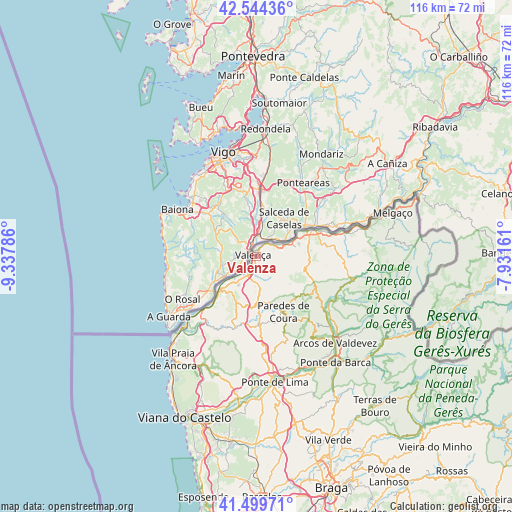
Valenza GPS coordinates[2]
42° 1' 27.048" North, 8° 38' 5.064" West
| Map corner | latitude | longitude |
|---|---|---|
| Upper-left | 42.54436°, | -9.33786° |
| Center: | 42.02418°, | -8.63474° |
| Lower-right: | 41.49971°, | -7.93161° |
| Map W x H: | 116.2×116.2 km | = 72.2×72.2mi |
| max Lat: | 42.11337° ⇑0.5% North |
| Valenza: | 42.02418° |
| min Lat: | ⇓99.5% South 32.6448° |
| min Long | Valenza | max Long |
| -31.17847° | -8.63474° | -6.27308° |
| W 42.5%⇐ | ⇒57.5% E |
Elevation
Elevation of Valenza is 48 m = 157 ft, and this is 129 m = 423 ft below average elevation for this country.
| Max E: |
1008 m = 3307 ft | 71% |
| Avg. | 177 m = 581 ft | |
| Valenza | 48 m = 157 ft | |
Min E: |
-128 m = -420 ft | 29% |
See also: Portugal elevation on elevation.city.
Geographical zone
Valenza is located in North temperate zone (between Tropic of Cancer and the Arctic Circle). Distance of this Northern Tropic circle is 2066.7 km =1284.2 mi to South.| Distance of | km | miles | from Valenza |
|---|---|---|---|
| North Pole | 5334.4 | 3314.6 | to North |
| Arctic Circle | 2728.5 | 1695.4 | to North |
| Tropic Cancer | 2066.7 | 1284.2 | to South |
| Equator | 4672.7 | 2903.5 | to South |


Nearby cities:
15 places around Valenza: (largest is in red/bold)
• Aboim da Nóbrega
36.6 km =22.7 mi,  146°
146°
• Arcos de Valdevez
26.6 km =16.5 mi,  137°
137°
• Areosa
38.7 km =24 mi,  208°
208°
• Meadela
37.8 km =23.5 mi,  200°
200°
• Melgaço
32.5 km =20.2 mi,  72°
72°
• Monção
14.1 km =8.8 mi,  64°
64°
• Mozelos
26.2 km =16.3 mi,  131°
131°
• Paredes de Coura
14.1 km =8.8 mi, 154°
• Ponte da Barca
30.4 km =18.9 mi, 143°
• Ponte de Lima
28.9 km =18 mi,  171°
171°
• Rubiãis
14.3 km =8.9 mi,  176°
176°
• Valença
1.2 km =0.7 mi,  309°
309°
• Vila
39.3 km =24.4 mi,  88°
88°
• Vila Nova de Cerveira
12.8 km =8 mi,  223°
223°
• Vila Praia de Âncora
29.8 km =18.5 mi, 217°
Sources, notices
• [Note1] Compared only with cities in Portugal existing in our database
• [Src1] Map data: © OpenStreetMap contributors (CC-BY-SA)
• [Src2] Other city data from geonames.org with taken over terms of usage.
• [Src3] Geographical zone / Annual Mean Temperature by Robert A. Rohde @ Wikipedia
