Rio Tinto geodata
Rio Tinto (Porto) is a populated place; located in Portugal in Europe/Lisbon (GMT+1) time zone. With population of 49,966 people, there are 21 cities with bigger population in this country. Compared to other cities in Portugal, 77.1% of cities are located further ↓South; 50.5% of cities are located further ←West and 56.4% of cities have higher elevation than Rio Tinto. Note1


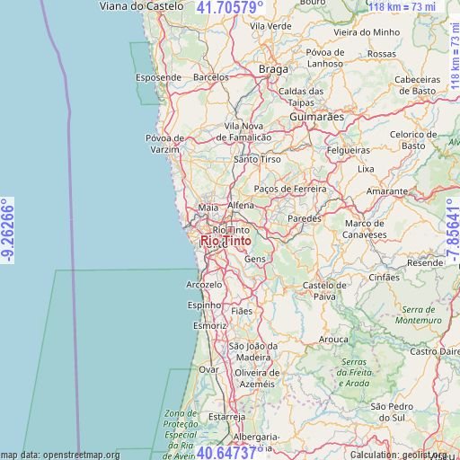
Rio Tinto GPS coordinates[2]
41° 10' 43.392" North, 8° 33' 34.308" West
| Map corner | latitude | longitude |
|---|---|---|
| Upper-left | 41.70579°, | -9.26266° |
| Center: | 41.17872°, | -8.55953° |
| Lower-right: | 40.64737°, | -7.85641° |
| Map W x H: | 117.7×117.7 km | = 73.1×73.1mi |
| max Lat: | 42.11337° ⇑22.9% North |
| Rio Tinto: | 41.17872° |
| min Lat: | ⇓77.1% South 32.6448° |
| min Long | Rio Tinto | max Long |
| -31.17847° | -8.55953° | -6.27308° |
| W 50.5%⇐ | ⇒49.5% E |
Elevation
Elevation of Rio Tinto is 88 m = 289 ft, and this is 89 m = 292 ft below average elevation for this country.
| Max E: |
1008 m = 3307 ft | 56.4% |
| Avg. | 177 m = 581 ft | |
| Rio Tinto | 88 m = 289 ft | |
Min E: |
-128 m = -420 ft | 43.6% |
See also: Rio Tinto elevation on elevation.city.
Geographical zone
Rio Tinto is located in North temperate zone (between Tropic of Cancer and the Arctic Circle). Distance of this Northern Tropic circle is 1972.7 km =1225.8 mi to South.| Distance of | km | miles | from Rio Tinto |
|---|---|---|---|
| North Pole | 5428.4 | 3373.1 | to North |
| Arctic Circle | 2822.5 | 1753.8 | to North |
| Tropic Cancer | 1972.7 | 1225.8 | to South |
| Equator | 4578.6 | 2845 | to South |


Nearby cities:
15 places around Rio Tinto: (largest is in red/bold)
• Alfena
7.1 km =4.4 mi,  24°
24°
• Baguim do Monte
2.1 km =1.3 mi,  46°
46°
• Ermesinde
4.2 km =2.6 mi,  7°
7°
• Fânzeres
2.8 km =1.7 mi,  116°
116°
• Gondomar
4.4 km =2.7 mi,  148°
148°
• Leça do Bailio
7.3 km =4.5 mi,  300°
300°
• Milheirós
4.7 km =2.9 mi,  328°
328°
• Oliveira do Douro
6.4 km =4 mi,  199°
199°
• Pedrouços
2.5 km =1.6 mi, 296°
• Porto
5.4 km =3.4 mi,  233°
233°
• São Mamede de Infesta
4.6 km =2.9 mi,  288°
288°
• São Pedro da Cova
6.3 km =3.9 mi,  128°
128°
• Valbom
5.5 km =3.4 mi,  182°
182°
• Valongo
5.2 km =3.2 mi,  77°
77°
• Águas Santas
3.8 km =2.4 mi,  338°
338°
Sources, notices
• [Note1] Compared only with cities in Portugal existing in our database
• [Src1] Map data: © OpenStreetMap contributors (CC-BY-SA)
• [Src2] Other city data from geonames.org with taken over terms of usage.
• [Src3] Geographical zone / Annual Mean Temperature by Robert A. Rohde @ Wikipedia
