Gondomar geodata
Gondomar (Porto) is a seat of a second-order administrative division; located in Portugal in Europe/Lisbon (GMT+1) time zone. With population of 27,691 people, there are 60 cities with bigger population in this country. Compared to other cities in Portugal, 75.7% of cities are located further ↓South; 52.3% of cities are located further ←West and 50.7% of cities have lower elevation than Gondomar. Note1


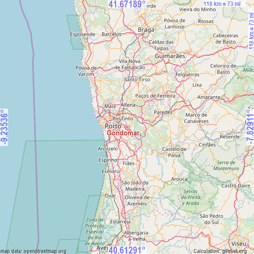
Gondomar GPS coordinates[2]
41° 8' 40.344" North, 8° 31' 56.028" West
| Map corner | latitude | longitude |
|---|---|---|
| Upper-left | 41.67189°, | -9.23536° |
| Center: | 41.14454°, | -8.53223° |
| Lower-right: | 40.61291°, | -7.82911° |
| Map W x H: | 117.7×117.7 km | = 73.1×73.1mi |
| max Lat: | 42.11337° ⇑24.3% North |
| Gondomar: | 41.14454° |
| min Lat: | ⇓75.7% South 32.6448° |
| min Long | Gondomar | max Long |
| -31.17847° | -8.53223° | -6.27308° |
| W 52.3%⇐ | ⇒47.7% E |
Elevation
Elevation of Gondomar is 116 m = 381 ft, and this is 61 m = 200 ft below average elevation for this country.
| Max E: |
1008 m = 3307 ft | 49.3% |
| Avg. | 177 m = 581 ft | |
| Gondomar | 116 m = 381 ft | |
Min E: |
-128 m = -420 ft | 50.7% |
See also: Portugal elevation on elevation.city.
Geographical zone
Gondomar is located in North temperate zone (between Tropic of Cancer and the Arctic Circle). Distance of this Northern Tropic circle is 1968.9 km =1223.4 mi to South.| Distance of | km | miles | from Gondomar |
|---|---|---|---|
| North Pole | 5432.2 | 3375.4 | to North |
| Arctic Circle | 2826.3 | 1756.2 | to North |
| Tropic Cancer | 1968.9 | 1223.4 | to South |
| Equator | 4574.8 | 2842.6 | to South |


Nearby cities:
15 places around Gondomar: (largest is in red/bold)
• Avintes
4.5 km =2.8 mi,  201°
201°
• Baguim do Monte
5.3 km =3.3 mi,  351°
351°
• Campo
7.2 km =4.5 mi,  51°
51°
• Foz do Sousa
5.9 km =3.7 mi,  154°
154°
• Fânzeres
2.6 km =1.6 mi,  4°
4°
• Jovim
3.9 km =2.4 mi,  163°
163°
• Oliveira do Douro
4.9 km =3 mi,  243°
243°
• Pedrouços
6.7 km =4.2 mi,  317°
317°
• Porto
6.6 km =4.1 mi,  274°
274°
• Rio Tinto
4.4 km =2.7 mi,  328°
328°
• São Pedro da Cova
2.7 km =1.7 mi,  92°
92°
• Valbom
3 km =1.9 mi, 235°
• Valongo
5.7 km =3.5 mi,  29°
29°
• Vila Nova de Gaia
7.1 km =4.4 mi,  251°
251°
• Vilar de Andorinho
6.2 km =3.9 mi,  226°
226°
Sources, notices
• [Note1] Compared only with cities in Portugal existing in our database
• [Src1] Map data: © OpenStreetMap contributors (CC-BY-SA)
• [Src2] Other city data from geonames.org with taken over terms of usage.
• [Src3] Geographical zone / Annual Mean Temperature by Robert A. Rohde @ Wikipedia
