Prado geodata
Prado (Braga) is a populated place; located in Portugal in Europe/Lisbon (GMT+1) time zone. With population of 4,518 people, there are 469 cities with bigger population in this country. Compared to other cities in Portugal, 95.9% of cities are located further ↓South; 57.7% of cities are located further ←West and 81.8% of cities have higher elevation than Prado. Note1


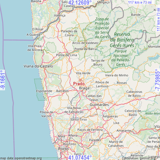
Prado GPS coordinates[2]
41° 36' 8.856" North, 8° 27' 46.692" West
| Map corner | latitude | longitude |
|---|---|---|
| Upper-left | 42.12609°, | -9.1661° |
| Center: | 41.60246°, | -8.46297° |
| Lower-right: | 41.07454°, | -7.75985° |
| Map W x H: | 116.9×116.9 km | = 72.6×72.6mi |
| max Lat: | 42.11337° ⇑4.1% North |
| Prado: | 41.60246° |
| min Lat: | ⇓95.9% South 32.6448° |
| min Long | Prado | max Long |
| -31.17847° | -8.46297° | -6.27308° |
| W 57.7%⇐ | ⇒42.3% E |
Elevation
Elevation of Prado is 30 m = 98 ft, and this is 147 m = 482 ft below average elevation for this country.
| Max E: |
1008 m = 3307 ft | 81.8% |
| Avg. | 177 m = 581 ft | |
| Prado | 30 m = 98 ft | |
Min E: |
-128 m = -420 ft | 18.2% |
See also: Portugal elevation on elevation.city.
Geographical zone
Prado is located in North temperate zone (between Tropic of Cancer and the Arctic Circle). Distance of this Northern Tropic circle is 2019.8 km =1255 mi to South.| Distance of | km | miles | from Prado |
|---|---|---|---|
| North Pole | 5381.3 | 3343.8 | to North |
| Arctic Circle | 2775.4 | 1724.6 | to North |
| Tropic Cancer | 2019.8 | 1255 | to South |
| Equator | 4625.8 | 2874.3 | to South |


Nearby cities:
15 places around Prado: (largest is in red/bold)
• Adaúfe
5.6 km =3.5 mi,  107°
107°
• Amares
9.8 km =6.1 mi,  71°
71°
• Arcos
9.6 km =6 mi,  158°
158°
• Aveleda
9 km =5.6 mi,  182°
182°
• Braga
6.8 km =4.2 mi,  148°
148°
• Ferreiros
8.8 km =5.5 mi, 68°
• Frossos
4.2 km =2.6 mi,  166°
166°
• Gondizalves
6.8 km =4.2 mi, 174°
• Lago
4.7 km =2.9 mi,  63°
63°
• Merelim
1.9 km =1.2 mi,  186°
186°
• Real
5.2 km =3.2 mi, 161°
• Rendufe
5.4 km =3.4 mi, 56°
• Semelhe
5.3 km =3.3 mi, 179°
• Vila Verde
5.4 km =3.4 mi,  23°
23°
• Vilaça
9.6 km =6 mi, 190°
Sources, notices
• [Note1] Compared only with cities in Portugal existing in our database
• [Src1] Map data: © OpenStreetMap contributors (CC-BY-SA)
• [Src2] Other city data from geonames.org with taken over terms of usage.
• [Src3] Geographical zone / Annual Mean Temperature by Robert A. Rohde @ Wikipedia
