Adaúfe geodata
Adaúfe (Braga) is a populated place; located in Portugal in Europe/Lisbon (GMT+1) time zone. With population of 3,850 people, there are 535 cities with bigger population in this country. Compared to other cities in Portugal, 95.8% of cities are located further ↓South; 63.1% of cities are located further ←West and 50.3% of cities have lower elevation than Adaúfe. Note1


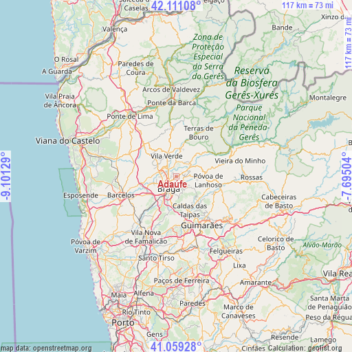
Adaúfe GPS coordinates[2]
41° 35' 14.352" North, 8° 23' 53.412" West
| Map corner | latitude | longitude |
|---|---|---|
| Upper-left | 42.11108°, | -9.10129° |
| Center: | 41.58732°, | -8.39817° |
| Lower-right: | 41.05928°, | -7.69504° |
| Map W x H: | 116.9×116.9 km | = 72.6×72.6mi |
| max Lat: | 42.11337° ⇑4.2% North |
| Adaúfe: | 41.58732° |
| min Lat: | ⇓95.8% South 32.6448° |
| min Long | Adaúfe | max Long |
| -31.17847° | -8.39817° | -6.27308° |
| W 63.1%⇐ | ⇒36.9% E |
Elevation
Elevation of Adaúfe is 115 m = 377 ft, and this is 62 m = 203 ft below average elevation for this country.
| Max E: |
1008 m = 3307 ft | 49.7% |
| Avg. | 177 m = 581 ft | |
| Adaúfe | 115 m = 377 ft | |
Min E: |
-128 m = -420 ft | 50.3% |
See also: Portugal elevation on elevation.city.
Geographical zone
Adaúfe is located in North temperate zone (between Tropic of Cancer and the Arctic Circle). Distance of this Northern Tropic circle is 2018.2 km =1254.1 mi to South.| Distance of | km | miles | from Adaúfe |
|---|---|---|---|
| North Pole | 5383 | 3344.8 | to North |
| Arctic Circle | 2777.1 | 1725.6 | to North |
| Tropic Cancer | 2018.2 | 1254.1 | to South |
| Equator | 4624.1 | 2873.3 | to South |


Nearby cities:
15 places around Adaúfe: (largest is in red/bold)
• Amares
6.2 km =3.9 mi,  38°
38°
• Arcos
7.5 km =4.7 mi,  194°
194°
• Aveleda
9.3 km =5.8 mi,  217°
217°
• Braga
4.5 km =2.8 mi,  203°
203°
• Esporões
8.7 km =5.4 mi, 190°
• Ferreiros
5.6 km =3.5 mi,  30°
30°
• Frossos
5 km =3.1 mi,  241°
241°
• Gondizalves
7 km =4.3 mi, 223°
• Lago
4 km =2.5 mi,  342°
342°
• Merelim
5.6 km =3.5 mi,  268°
268°
• Prado
5.6 km =3.5 mi,  287°
287°
• Real
4.9 km =3 mi,  229°
229°
• Rendufe
4.7 km =2.9 mi,  349°
349°
• Semelhe
6.5 km =4 mi, 235°
• Vila Verde
7.4 km =4.6 mi,  334°
334°
Sources, notices
• [Note1] Compared only with cities in Portugal existing in our database
• [Src1] Map data: © OpenStreetMap contributors (CC-BY-SA)
• [Src2] Other city data from geonames.org with taken over terms of usage.
• [Src3] Geographical zone / Annual Mean Temperature by Robert A. Rohde @ Wikipedia
