Arcos geodata
Arcos (Braga) is a populated place; located in Portugal in Europe/Lisbon (GMT+1) time zone. With population of 6,805 people, there are 325 cities with bigger population in this country. Compared to other cities in Portugal, 93.6% of cities are located further ↓South; 61% of cities are located further ←West and 62.4% of cities have lower elevation than Arcos. Note1


Arcos GPS coordinates[2]
41° 31' 18.66" North, 8° 25' 17.436" West
| Map corner | latitude | longitude |
|---|---|---|
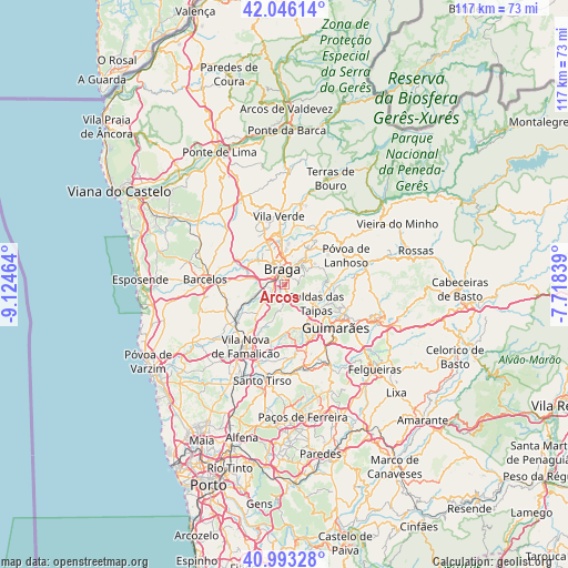
| Upper-left | 42.04614°, | -9.12464° |
| Center: | 41.52185°, | -8.42151° |
| Lower-right: | 40.99328°, | -7.71839° |
| Map W x H: | 117.1×117.1 km | = 72.8×72.8mi |
| max Lat: | 42.11337° ⇑6.4% North |
| Arcos: | 41.52185° |
| min Lat: | ⇓93.6% South 32.6448° |
| min Long | Arcos | max Long |
| -31.17847° | -8.42151° | -6.27308° |
| W 61%⇐ | ⇒39% E |
Elevation
Elevation of Arcos is 167 m = 548 ft, and this is 10 m = 33 ft below average elevation for this country.
| Max E: |
1008 m = 3307 ft | 37.6% |
| Avg. | 177 m = 581 ft | |
| Arcos | 167 m = 548 ft | |
Min E: |
-128 m = -420 ft | 62.4% |
See also: Portugal elevation on elevation.city.
Geographical zone
Arcos is located in North temperate zone (between Tropic of Cancer and the Arctic Circle). Distance of this Northern Tropic circle is 2010.9 km =1249.5 mi to South.| Distance of | km | miles | from Arcos |
|---|---|---|---|
| North Pole | 5390.3 | 3349.4 | to North |
| Arctic Circle | 2784.4 | 1730.1 | to North |
| Tropic Cancer | 2010.9 | 1249.5 | to South |
| Equator | 4616.8 | 2868.7 | to South |


Nearby cities:
15 places around Arcos: (largest is in red/bold)
• Adaúfe
7.5 km =4.7 mi,  14°
14°
• Aveleda
3.8 km =2.4 mi,  268°
268°
• Braga
3.2 km =2 mi,  2°
2°
• Caldas das Taipas
7.4 km =4.6 mi,  124°
124°
• Esporões
1.4 km =0.9 mi,  164°
164°
• Frossos
5.5 km =3.4 mi,  333°
333°
• Gondizalves
3.6 km =2.2 mi,  307°
307°
• Guisande
4.8 km =3 mi,  204°
204°
• Lamas
2.4 km =1.5 mi,  206°
206°
• Merelim
8 km =5 mi, 332°
• Oliveira
6.3 km =3.9 mi,  219°
219°
• Real
4.5 km =2.8 mi,  335°
335°
• Semelhe
5 km =3.1 mi,  316°
316°
• Tebosa
6.8 km =4.2 mi,  229°
229°
• Vilaça
5.2 km =3.2 mi, 265°
Sources, notices
• [Note1] Compared only with cities in Portugal existing in our database
• [Src1] Map data: © OpenStreetMap contributors (CC-BY-SA)
• [Src2] Other city data from geonames.org with taken over terms of usage.
• [Src3] Geographical zone / Annual Mean Temperature by Robert A. Rohde @ Wikipedia
